Title:
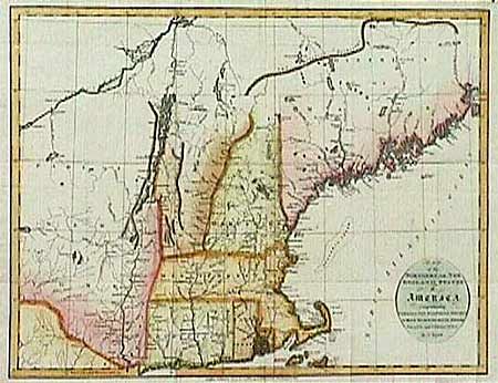
“Map of the Northern, or New England States of America Comprehending Vermont, New Hampshire, District of Maine, Massachusetts, Rhode Island, and Connecticut”
Map Maker:
John Russell
A very attractive copper engraved map of New Engla... (full text available to subscribers)
| Item Detail |
| |
| |
MapMaker: |
John Russell
|
|
| |
| |
Subject: |
Northeastern United States |
|
| |
Period/Size: |
1795 / 14.2" x 17.7" (36.1 x 45.0 cm)
|
|
| |
Color: |
Colored
|
|
| |
Condition: |
(A+) Issued folded and now pressed and ready for framing. (condition help) |
|
| |
Source: |
|
|
| |
References: |
|
|
| |
|
|
| Sales Information |
| |
| |
Price: |
|
|
| |
| |
Offered by: |
Old World Auctions |
|
| |
Catalog: |
Auction No. 89 - Antique Maps, Charts, Atlases & Globes (161) |
|
| |
Lot/Item #: |
90 |
|
| |
| |
Date: |
12/1999
|
|
| |
| |
|
Antique Maps - Valuation and Pricing, Descriptions, Resources |
|
Home |
Information |
Search |
Register |
Contact Us |
Site Map
Americana Exchange, Inc. © 1999 - 2024 Americana Exchange, Inc.. All rights reserved.
OldMaps.com, the OldMaps.com logo and
AMPR are service marks or registered service marks of Americana Exchange, Inc..
|