Title:
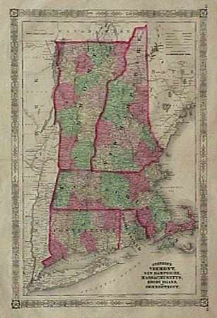
“Johnson's Vermont, New Hampshire, Massachusetts, Rhode Island, and Connecticut”
Map Maker:
Alvin Jewitt Johnson [& Co.]
Double sheet, vertical map with good coloring, de... (full text available to subscribers)
| Item Detail |
| |
| |
MapMaker: |
Alvin Jewitt Johnson [& Co.]
|
|
| |
| |
Subject: |
Eastern United States |
|
| |
Period/Size: |
1864 / 21.3" x 14.5" (54.1 x 36.9 cm)
|
|
| |
Color: |
Colored
|
|
| |
Condition: |
(B) Several margin tears and separations on fold top and bottom all repaired with archival tape. Faint foxing in margins, otherwise very good. (condition help) |
|
| |
Source: |
|
|
| |
References: |
|
|
| |
|
|
| Sales Information |
| |
| |
Price: |
|
|
| |
| |
Offered by: |
Old World Auctions |
|
| |
Catalog: |
Auction No. 88 - Antique Maps, Charts, Atlases & Globes (160) |
|
| |
Lot/Item #: |
90 |
|
| |
| |
Date: |
10/1999
|
|
| |
| |
|
Antique Maps - Valuation and Pricing, Descriptions, Resources |
|
Home |
Information |
Search |
Register |
Contact Us |
Site Map
Americana Exchange, Inc. © 1999 - 2024 Americana Exchange, Inc.. All rights reserved.
OldMaps.com, the OldMaps.com logo and
AMPR are service marks or registered service marks of Americana Exchange, Inc..
|