Title:
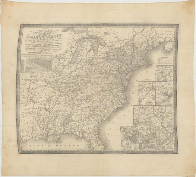
“Mitchell's Map of the United States; Showing the Principal Travelling, Turnpike and Common Roads; on Which Are Given the Distances in Miles from One Place to Another…”
Map Maker:
Samuel Augustus Mitchell
This extremely rare map is the only Mitchell publi... (full text available to subscribers)
| Item Detail |
| |
| |
MapMaker: |
Samuel Augustus Mitchell
|
|
| |
| |
Subject: |
Eastern United States |
|
| |
Period/Size: |
1836 / 19.1" x 23.6" (48.6 x 60.0 cm)
|
|
| |
Color: |
Black & White
|
|
| |
Condition: |
(B+) Overall very good with just a few small stains in the image and minor soiling in the blank margins. The map image is slightly non-rectangular due to the challenge of printing on cloth. (condition help) |
|
| |
Source: |
|
|
| |
References: |
Rumsey #4544; cf. Phillips (Maps) p. 889. |
|
| |
|
|
| Sales Information |
| |
| |
Price: |
|
|
| |
| |
Offered by: |
Old World Auctions |
|
| |
Catalog: |
Auction No. 155 - Antique Maps, Charts, Atlases & Globes (9278) |
|
| |
Lot/Item #: |
142 |
|
| |
| |
Date: |
11/2015
|
|
| |
| |
|
Antique Maps - Valuation and Pricing, Descriptions, Resources |
|
Home |
Information |
Search |
Register |
Contact Us |
Site Map
Americana Exchange, Inc. © 1999 - 2024 Americana Exchange, Inc.. All rights reserved.
OldMaps.com, the OldMaps.com logo and
AMPR are service marks or registered service marks of Americana Exchange, Inc..
|