Title:
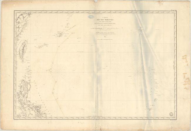
“Carte des Iles Mariannes et des Terres Environnantes (Iles Philippines, Formose, Madjico-Sima, Lou-Chou, Bonin-Sima, &c.)...”
Map Maker:
Jules Sebastian Cesar Dumont d'Urville
This large French chart by Clement Adrien Vincendo... (full text available to subscribers)
| Item Detail |
| |
| |
MapMaker: |
Jules Sebastian Cesar Dumont d'Urville
|
|
| |
| |
Subject: |
Mariana Islands, Taiwan, & Northern Philippines |
|
| |
Period/Size: |
1847 / 23.8" x 35.4" (60.5 x 90.0 cm)
|
|
| |
Color: |
Black & White
|
|
| |
Condition: |
(B) This example includes the stamp of "Francois Roux Hydrographe - Marseille" and sepia manuscript notations charting a course through the sea. There is light soiling, extraneous creasing at right, and a 5" centerfold separation at bottom that has been (condition help) |
|
| |
Source: |
Voyage au Pole Sud et dans l'Oceanie... |
|
| |
References: |
Phillips (Atlases) #1197-44. |
|
| |
|
|
| Sales Information |
| |
| |
Price: |
|
|
| |
| |
Offered by: |
Old World Auctions |
|
| |
Catalog: |
Auction No. 191 - Antique Maps, Charts, Atlases & Globes (9561) |
|
| |
Lot/Item #: |
772 |
|
| |
| |
Date: |
02/2023
|
|
| |
| |
|
Antique Maps - Valuation and Pricing, Descriptions, Resources |
|
Home |
Information |
Search |
Register |
Contact Us |
Site Map
Americana Exchange, Inc. © 1999 - 2024 Americana Exchange, Inc.. All rights reserved.
OldMaps.com, the OldMaps.com logo and
AMPR are service marks or registered service marks of Americana Exchange, Inc..
|