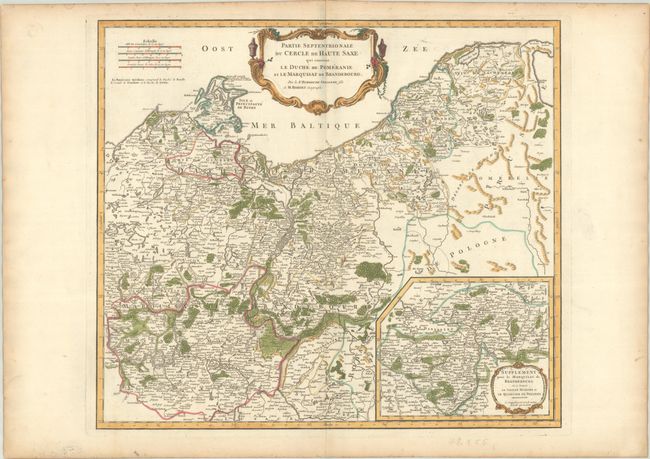
Title:
“Partie Septentrionale du Cercle de Haute Saxe qui Contient le Duche de Pomeranie et le Marquisat de Brandebourg”
Map Maker:
Didier Robert de Vaugondy
This handsome map depicts the historical region of... (full text available to subscribers)
| Item Detail |
| |
| |
MapMaker: |
Didier Robert de Vaugondy
|
|
| |
| |
Subject: |
Northeastern Germany & Northwestern Poland |
|
| |
Period/Size: |
1760 / 19.0" x 21.6" (48.3 x 54.9 cm)
|
|
| |
Color: |
Colored
|
|
| |
Condition: |
(A) A crisp impression on a bright sheet with a small birdhouse watermark, with contemporary outline color that has been augmented with modern coloring. There is marginal soiling and toning. (condition help) |
|
| |
Source: |
Atlas Universel |
|
| |
References: |
Pedley #264. |
|
| |
|
|
| Sales Information |
| |
| |
Price: |
|
|
| |
| |
Offered by: |
Old World Auctions |
|
| |
Catalog: |
Auction No. 191 - Antique Maps, Charts, Atlases & Globes (9561) |
|
| |
Lot/Item #: |
551 |
|
| |
| |
Date: |
02/2023
|
|
| |
| |
|
Antique Maps - Valuation and Pricing, Descriptions, Resources |
|
Home |
Information |
Search |
Register |
Contact Us |
Site Map
Americana Exchange, Inc. © 1999 - 2024 Americana Exchange, Inc.. All rights reserved.
OldMaps.com, the OldMaps.com logo and
AMPR are service marks or registered service marks of Americana Exchange, Inc..
|