Title:
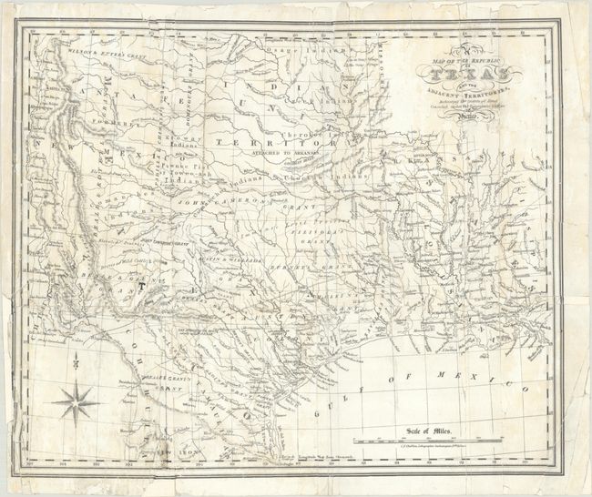
“A Map of the Republic of Texas and the Adjacent Territories Indicating the Grants of Land Conceded Under the Empresario System of Mexico”
Map Maker:
William Kennedy
This detailed map of the Republic of Texas ... (full text available to subscribers)
| Item Detail |
| |
| |
MapMaker: |
William Kennedy
|
|
| |
| |
Subject: |
Republic of Texas |
|
| |
Period/Size: |
1841 / 12.4" x 14.9" (31.5 x 37.9 cm)
|
|
| |
Color: |
Black & White
|
|
| |
Condition: |
(C+) Issued folding and now flat with numerous tears and separations throughout that have been closed on verso with archival tape. Several small areas of border and some lettering in the map have been replaced in facsimile. Light staining. (condition help) |
|
| |
Source: |
|
|
| |
References: |
Howes #K-92; Sabin #37440; Streeter (Texas) #1385. |
|
| |
|
|
| Sales Information |
| |
| |
Price: |
|
|
| |
| |
Offered by: |
Old World Auctions |
|
| |
Catalog: |
Auction No. 192 - Antique Maps, Charts, Atlases & Globes (9562) |
|
| |
Lot/Item #: |
296 |
|
| |
| |
Date: |
04/2023
|
|
| |
| |
|
Antique Maps - Valuation and Pricing, Descriptions, Resources |
|
Home |
Information |
Search |
Register |
Contact Us |
Site Map
Americana Exchange, Inc. © 1999 - 2024 Americana Exchange, Inc.. All rights reserved.
OldMaps.com, the OldMaps.com logo and
AMPR are service marks or registered service marks of Americana Exchange, Inc..
|