Title:
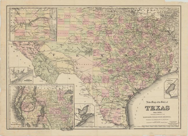
“New Map of the State of Texas for 1878...”
Map Maker:
G.W. & C.B. Colton & Co.
This scarce, separately published map of the state... (full text available to subscribers)
| Item Detail |
| |
| |
MapMaker: |
G.W. & C.B. Colton & Co.
|
|
| |
| |
Subject: |
Texas |
|
| |
Period/Size: |
1878 / 18.3" x 25.3" (46.5 x 64.3 cm)
|
|
| |
Color: |
Colored
|
|
| |
Condition: |
(B+) Issued folding on thin paper with minor foxing. There are several archivally repaired small fold separations along the sheet edges, including one at lower left that extends 3.5" into the image with minor image loss. (condition help) |
|
| |
Source: |
Hanford's Texas State Register |
|
| |
References: |
cf. Taliaferro (Rosenberg) #352 & #367. |
|
| |
|
|
| Sales Information |
| |
| |
Price: |
|
|
| |
| |
Offered by: |
Old World Auctions |
|
| |
Catalog: |
Auction No. 181 - Antique Maps, Charts, Atlases & Globes (9527) |
|
| |
Lot/Item #: |
287 |
|
| |
| |
Date: |
02/2021
|
|
| |
| |
|
Antique Maps - Valuation and Pricing, Descriptions, Resources |
|
Home |
Information |
Search |
Register |
Contact Us |
Site Map
Americana Exchange, Inc. © 1999 - 2024 Americana Exchange, Inc.. All rights reserved.
OldMaps.com, the OldMaps.com logo and
AMPR are service marks or registered service marks of Americana Exchange, Inc..
|