Title:
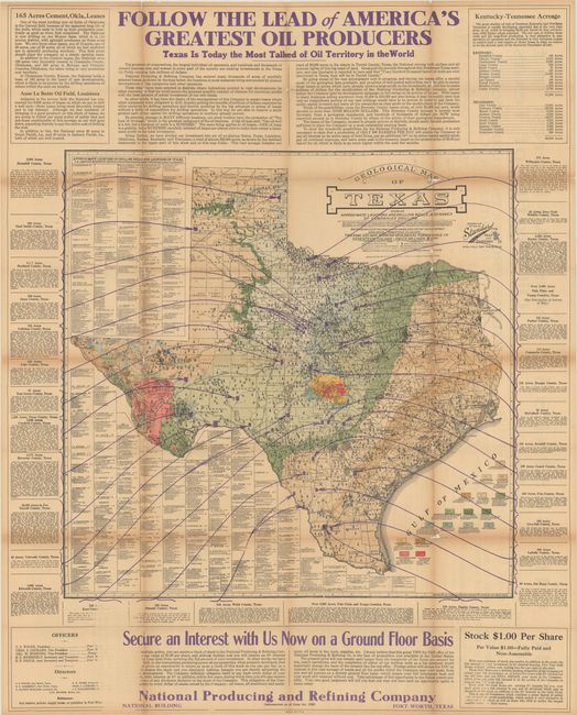
“Geological Map of Texas Showing Approximate Locations and Drilling Wells, Also Names of Companies Drilling”
Map Maker:
Standard, Blue Print, Map & Engineering Co.
This large map focuses on the burgeoning oil and g... (full text available to subscribers)
| Item Detail |
| |
| |
MapMaker: |
Standard, Blue Print, Map & Engineering Co.
|
|
| |
| |
Subject: |
Texas, Oil Fields |
|
| |
Period/Size: |
1920 / 25.2" x 25.8" (64.0 x 65.6 cm)
|
|
| |
Color: |
Colored
|
|
| |
Condition: |
(B) Issued folding on thin paper with light toning and numerous small splits and tears along the folds that have been partially closed on verso with archival tape. There is small loss at several fold junctions. (condition help) |
|
| |
Source: |
|
|
| |
References: |
|
|
| |
|
|
| Sales Information |
| |
| |
Price: |
|
|
| |
| |
Offered by: |
Old World Auctions |
|
| |
Catalog: |
Auction No. 184 - Antique Maps, Charts, Atlases & Globes (9549) |
|
| |
Lot/Item #: |
341 |
|
| |
| |
Date: |
09/2021
|
|
| |
| |
|
Antique Maps - Valuation and Pricing, Descriptions, Resources |
|
Home |
Information |
Search |
Register |
Contact Us |
Site Map
Americana Exchange, Inc. © 1999 - 2024 Americana Exchange, Inc.. All rights reserved.
OldMaps.com, the OldMaps.com logo and
AMPR are service marks or registered service marks of Americana Exchange, Inc..
|