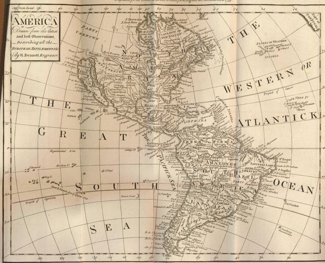
Title:
“America Drawn from the Latest and Best Observations Describing all the European Settlements”
Map Maker:
Richard Bennett
This rarity is a very late map to show Californ... (full text available to subscribers)
| Item Detail |
| |
| |
MapMaker: |
Richard Bennett
|
|
| |
| |
Subject: |
Western Hemisphere |
|
| |
Period/Size: |
1759 / 10.3" x 13.0" (26.2 x 33.1 cm)
|
|
| |
Color: |
Black & White
|
|
| |
Condition: |
Light shelf wear with small chip to lower edge of spine label and small piece missing from heel of spine. Binding tight and sound. The book is internally clean and unmarked with only rare instances of foxing. The America map has a short fold split repair (condition help) |
|
| |
Source: |
The Grand Magazine of Universal Intelligence… MDCCLIX |
|
| |
References: |
Jolly GMUI-10; McLaughlin #239. |
|
| |
|
|
| Sales Information |
| |
| |
Price: |
|
|
| |
| |
Offered by: |
Old World Auctions |
|
| |
Catalog: |
Auction No. 132 - Antique Maps, Charts, Atlases & Globes (7403) |
|
| |
Lot/Item #: |
76 |
|
| |
| |
Date: |
06/2010
|
|
| |
| |
|
Antique Maps - Valuation and Pricing, Descriptions, Resources |
|
Home |
Information |
Search |
Register |
Contact Us |
Site Map
Americana Exchange, Inc. © 1999 - 2024 Americana Exchange, Inc.. All rights reserved.
OldMaps.com, the OldMaps.com logo and
AMPR are service marks or registered service marks of Americana Exchange, Inc..
|