Title:
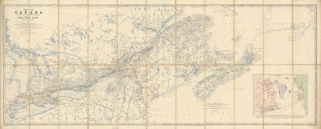
“Map of Canada with Part of New Brunswick & Nova Scotia. Shewing the Line of Grand Trunk Railway and its Connections”
Map Maker:
W. & A.K. Johnston
This rarely seen railroad map uses red overprintin... (full text available to subscribers)
| Item Detail |
| |
| |
MapMaker: |
W. & A.K. Johnston
|
|
| |
| |
Subject: |
Canada |
|
| |
Period/Size: |
1860 / 17.7" x 45.3" (45.0 x 115.1 cm)
|
|
| |
Color: |
Colored
|
|
| |
Condition: |
Map is near fine with a few splits on fold intersections of linen. (condition help) |
|
| |
Source: |
|
|
| |
References: |
|
|
| |
|
|
| Sales Information |
| |
| |
Price: |
|
|
| |
| |
Offered by: |
Old World Auctions |
|
| |
Catalog: |
Auction No. 132 - Antique Maps, Charts, Atlases & Globes (7403) |
|
| |
Lot/Item #: |
110 |
|
| |
| |
Date: |
06/2010
|
|
| |
| |
|
Antique Maps - Valuation and Pricing, Descriptions, Resources |
|
Home |
Information |
Search |
Register |
Contact Us |
Site Map
Americana Exchange, Inc. © 1999 - 2024 Americana Exchange, Inc.. All rights reserved.
OldMaps.com, the OldMaps.com logo and
AMPR are service marks or registered service marks of Americana Exchange, Inc..
|