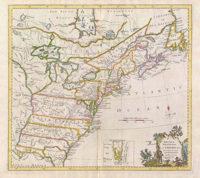
Title:
“British Dominions in America, Drawn from the latest and best Authorities”
Map Maker:
Thomas Kitchin
This handsome colonial period map covers the area ... (full text available to subscribers)
| Item Detail |
| |
| |
MapMaker: |
Thomas Kitchin
|
|
| |
| |
Subject: |
Colonial United States and Canada |
|
| |
Period/Size: |
1771 / 13.3" x 14.7" (33.8 x 37.4 cm)
|
|
| |
Color: |
Colored
|
|
| |
Condition: |
Nice impression with faint toning along the centerfold. (condition help) |
|
| |
Source: |
|
|
| |
References: |
McCorkle #780.6; Goss (NA) #64. |
|
| |
|
|
| Sales Information |
| |
| |
Price: |
|
|
| |
| |
Offered by: |
Old World Auctions |
|
| |
Catalog: |
Auction No. 132 - Antique Maps, Charts, Atlases & Globes (7403) |
|
| |
Lot/Item #: |
119 |
|
| |
| |
Date: |
06/2010
|
|
| |
| |
|
Antique Maps - Valuation and Pricing, Descriptions, Resources |
|
Home |
Information |
Search |
Register |
Contact Us |
Site Map
Americana Exchange, Inc. © 1999 - 2024 Americana Exchange, Inc.. All rights reserved.
OldMaps.com, the OldMaps.com logo and
AMPR are service marks or registered service marks of Americana Exchange, Inc..
|