Title:
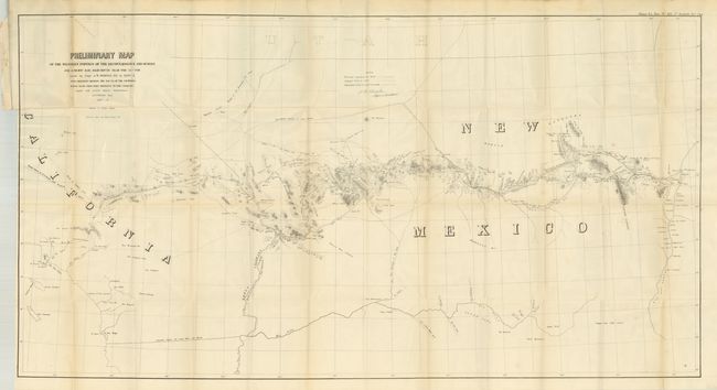
“Preliminary Map of the Western Portion of the Reconnaissance and Survey for a Pacific Railroad Route Near the 35th Parallel Made by Capt. A.W. Whipple. T.E. in 1853-4…”
Map Maker:
Amiel Weekes Whipple
This large lithographic map covers the region from... (full text available to subscribers)
| Item Detail |
| |
| |
MapMaker: |
Amiel Weekes Whipple
|
|
| |
| |
Subject: |
Southwestern United States |
|
| |
Period/Size: |
1858 / 26.2" x 40.0" (66.6 x 101.6 cm)
|
|
| |
Color: |
Black & White
|
|
| |
Condition: |
The map is surprisingly clean and bright for a map of this size. Some folds with small intersections splits that will benefit from backing. The report is tight and near fine less a third of the pages with edge water stains. Disbound report and the map (condition help) |
|
| |
Source: |
HR Doc. 124, 35th Cong. 1st sess. |
|
| |
References: |
Wheat [TMW] #939. |
|
| |
|
|
| Sales Information |
| |
| |
Price: |
|
|
| |
| |
Offered by: |
Old World Auctions |
|
| |
Catalog: |
Auction No. 132 - Antique Maps, Charts, Atlases & Globes (7403) |
|
| |
Lot/Item #: |
211 |
|
| |
| |
Date: |
06/2010
|
|
| |
| |
|
Antique Maps - Valuation and Pricing, Descriptions, Resources |
|
Home |
Information |
Search |
Register |
Contact Us |
Site Map
Americana Exchange, Inc. © 1999 - 2024 Americana Exchange, Inc.. All rights reserved.
OldMaps.com, the OldMaps.com logo and
AMPR are service marks or registered service marks of Americana Exchange, Inc..
|