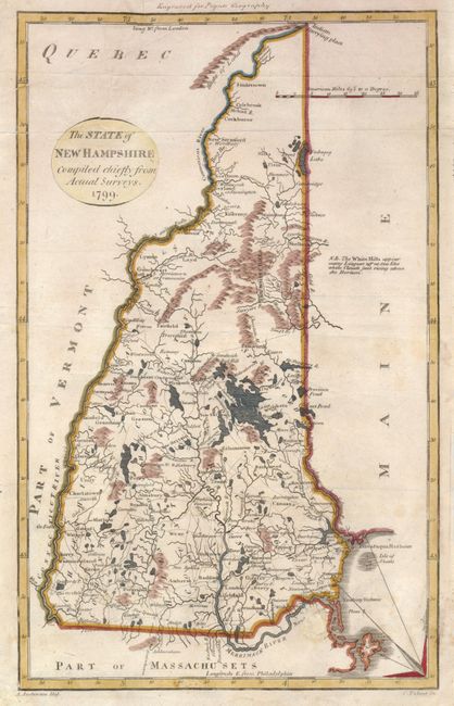
Title:
“The State of New Hampshire Compiled chiefly from Actual Surveys”
Map Maker:
Alexander Anderson
Finely engraved map showing the original five coun... (full text available to subscribers)
| Item Detail |
| |
| |
MapMaker: |
Alexander Anderson
|
|
| |
| |
Subject: |
New Hampshire |
|
| |
Period/Size: |
1799 / 11.6" x 7.3" (29.5 x 18.6 cm)
|
|
| |
Color: |
Colored
|
|
| |
Condition: |
A small hole below the Merrimack River has been filled and a 3" tear at the top of the cartouche has been repaired. (condition help) |
|
| |
Source: |
Payne's Geography |
|
| |
References: |
Cobb (NH) #78. |
|
| |
|
|
| Sales Information |
| |
| |
Price: |
|
|
| |
| |
Offered by: |
Old World Auctions |
|
| |
Catalog: |
Auction No. 132 - Antique Maps, Charts, Atlases & Globes (7403) |
|
| |
Lot/Item #: |
272 |
|
| |
| |
Date: |
06/2010
|
|
| |
| |
|
Antique Maps - Valuation and Pricing, Descriptions, Resources |
|
Home |
Information |
Search |
Register |
Contact Us |
Site Map
Americana Exchange, Inc. © 1999 - 2024 Americana Exchange, Inc.. All rights reserved.
OldMaps.com, the OldMaps.com logo and
AMPR are service marks or registered service marks of Americana Exchange, Inc..
|