Title:
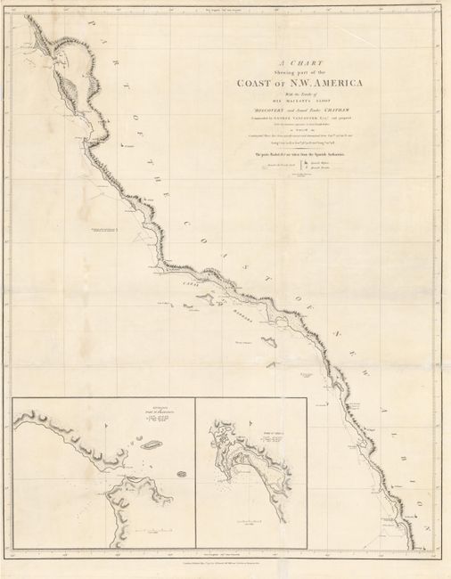
“A Chart Shewing Part of the Coast of N.W. America with the Tracks of His Majesty's Sloop Discovery ... from Lat. of 30°00' N. & Long. 244°32' E. to Lat. 38°30' N. & Long. 237°13' E. …”
Map Maker:
George Vancouver
This important chart (No. 8) records George Vanco... (full text available to subscribers)
| Item Detail |
| |
| |
MapMaker: |
George Vancouver
|
|
| |
| |
Subject: |
California and Baja Mexico |
|
| |
Period/Size: |
1798 / 30.8" x 24.5" (78.3 x 62.3 cm)
|
|
| |
Color: |
Black & White
|
|
| |
Condition: |
Generally clean and bright with some faint toning at left. The map has been folded and there are tissue reinforcements on the folds (some of which are on the face of the map) with small paper loss replaced affecting the place name Ya. De Sta. Rosa (condition help) |
|
| |
Source: |
Voyages of Discovery to the North Pacific Ocean |
|
| |
References: |
Heckrotte & Sweetkind #18; Wagner (NW) 856. |
|
| |
|
|
| Sales Information |
| |
| |
Price: |
|
|
| |
| |
Offered by: |
Old World Auctions |
|
| |
Catalog: |
Auction No. 132 - Antique Maps, Charts, Atlases & Globes (7403) |
|
| |
Lot/Item #: |
320 |
|
| |
| |
Date: |
06/2010
|
|
| |
| |
|
Antique Maps - Valuation and Pricing, Descriptions, Resources |
|
Home |
Information |
Search |
Register |
Contact Us |
Site Map
Americana Exchange, Inc. © 1999 - 2024 Americana Exchange, Inc.. All rights reserved.
OldMaps.com, the OldMaps.com logo and
AMPR are service marks or registered service marks of Americana Exchange, Inc..
|