Title:
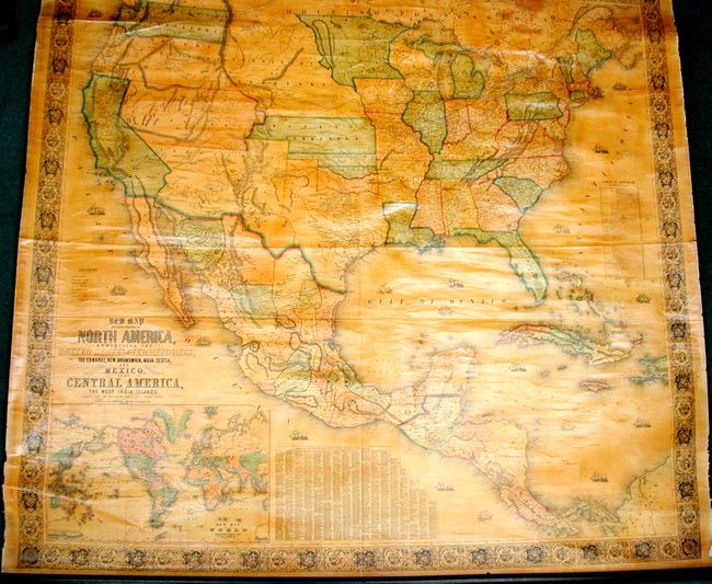
“New Map of the Portion of North America, Exhibiting the United States and Territories, The Canadas, New Brunswick, Nova Scotia, and Mexico also Central America, and the West India Islands. Compiled from the Most Recent Surveys and Authentic Sources”
Map Maker:
Jacob Monk
This majestic wall map was published just as the c... (full text available to subscribers)
| Item Detail |
| |
| |
MapMaker: |
Jacob Monk
|
|
| |
| |
Subject: |
United States & Mexico |
|
| |
Period/Size: |
1854 / 55.8" x 59.0" (141.8 x 149.9 cm)
|
|
| |
Color: |
Colored
|
|
| |
Condition: |
This is a beautiful example whose image is fine with no flaws. There is a small area at upper left of marginal roughness in blank margin. Some typical cracking along the upper edge next to the roller. Small area of water stain at upper right corner. (condition help) |
|
| |
Source: |
|
|
| |
References: |
Wheat (TMW) #794; Wheat (GOLD) #243; Rumsey #602. |
|
| |
|
|
| Sales Information |
| |
| |
Price: |
|
|
| |
| |
Offered by: |
Old World Auctions |
|
| |
Catalog: |
Auction No. 132 - Antique Maps, Charts, Atlases & Globes (7403) |
|
| |
Lot/Item #: |
322 |
|
| |
| |
Date: |
06/2010
|
|
| |
| |
|
Antique Maps - Valuation and Pricing, Descriptions, Resources |
|
Home |
Information |
Search |
Register |
Contact Us |
Site Map
Americana Exchange, Inc. © 1999 - 2024 Americana Exchange, Inc.. All rights reserved.
OldMaps.com, the OldMaps.com logo and
AMPR are service marks or registered service marks of Americana Exchange, Inc..
|