Title:
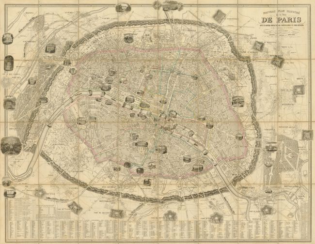
“Nouveau Plan Illustre de la Ville de Paris avec le Systeme Complet de ses Fortifications et Forts Detache, et des Communes de la Banlieue”
Map Maker:
Alexander A. Vuillemin
This great plan of Paris conveys a wonderful amoun... (full text available to subscribers)
| Item Detail |
| |
| |
MapMaker: |
Alexander A. Vuillemin
|
|
| |
| |
Subject: |
Paris, France |
|
| |
Period/Size: |
1853 / 33.3" x 42.8" (84.6 x 108.8 cm)
|
|
| |
Color: |
Colored
|
|
| |
Condition: |
Original outline color with one separation of the linen at right. There is a small defect in the case, likely the result of a hungry rodent. (condition help) |
|
| |
Source: |
|
|
| |
References: |
|
|
| |
|
|
| Sales Information |
| |
| |
Price: |
|
|
| |
| |
Offered by: |
Old World Auctions |
|
| |
Catalog: |
Auction No. 132 - Antique Maps, Charts, Atlases & Globes (7403) |
|
| |
Lot/Item #: |
481 |
|
| |
| |
Date: |
06/2010
|
|
| |
| |
|
Antique Maps - Valuation and Pricing, Descriptions, Resources |
|
Home |
Information |
Search |
Register |
Contact Us |
Site Map
Americana Exchange, Inc. © 1999 - 2024 Americana Exchange, Inc.. All rights reserved.
OldMaps.com, the OldMaps.com logo and
AMPR are service marks or registered service marks of Americana Exchange, Inc..
|