Title:
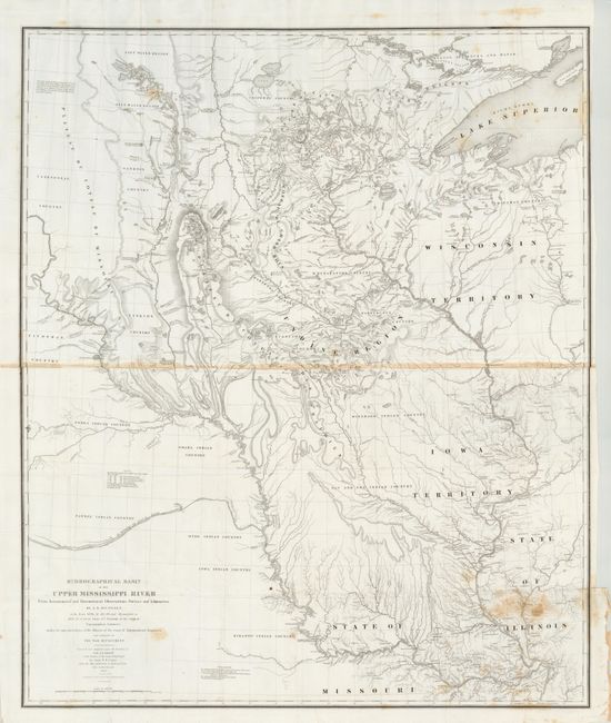
“Hydrographical Basin of the Upper Mississippi River from Astronomical and Barometrical Observations Surveys and Information…”
Map Maker:
U.S. War Department
This extremely important map is the first accurate... (full text available to subscribers)
| Item Detail |
| |
| |
MapMaker: |
U.S. War Department
|
|
| |
| |
Subject: |
United States - Midwest |
|
| |
Period/Size: |
1843 / 36.0" x 30.0" (91.5 x 76.2 cm)
|
|
| |
Color: |
Black & White
|
|
| |
Condition: |
The majority of the map image is fine with a crisp impression on clean paper. The paper join is toned across the middle and there is an area of toning or staining at lower right corner that is lightly mirrored in upper right corner. Original full margin (condition help) |
|
| |
Source: |
House Doc 52, 28th Congress. 2nd Sess. |
|
| |
References: |
Schwartz and Ehrenberg plt. 165. |
|
| |
|
|
| Sales Information |
| |
| |
Price: |
|
|
| |
| |
Offered by: |
Old World Auctions |
|
| |
Catalog: |
Auction No. 133 - Antique Maps, Charts, Atlases & Globes (7404) |
|
| |
Lot/Item #: |
175 |
|
| |
| |
Date: |
09/2010
|
|
| |
| |
|
Antique Maps - Valuation and Pricing, Descriptions, Resources |
|
Home |
Information |
Search |
Register |
Contact Us |
Site Map
Americana Exchange, Inc. © 1999 - 2024 Americana Exchange, Inc.. All rights reserved.
OldMaps.com, the OldMaps.com logo and
AMPR are service marks or registered service marks of Americana Exchange, Inc..
|