Title:
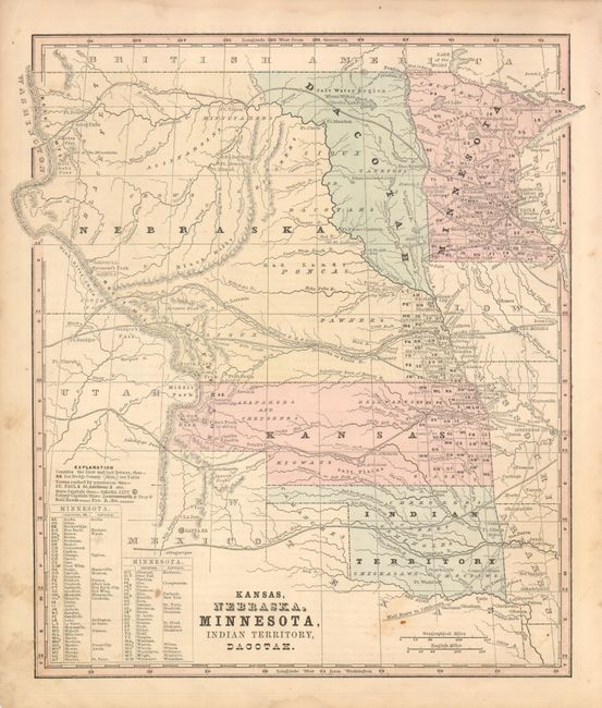
“Kansas, Nebraska, Minnesota, Indian Territory, Dacotah”
Map Maker:
Roswell Chamberlain Smith [& Co.]
This map's main feature is the desirable depiction... (full text available to subscribers)
| Item Detail |
| |
| |
MapMaker: |
Roswell Chamberlain Smith [& Co.]
|
|
| |
| |
Subject: |
United States - Midwest |
|
| |
Period/Size: |
1860-62 / 11.8" x 10.7" (30.0 x 27.2 cm)
|
|
| |
Color: |
Colored
|
|
| |
Condition: |
A little marginal soiling or staining, map image is very good less some soiling at lower right. (condition help) |
|
| |
Source: |
Smith's Geography |
|
| |
References: |
|
|
| |
|
|
| Sales Information |
| |
| |
Price: |
|
|
| |
| |
Offered by: |
Old World Auctions |
|
| |
Catalog: |
Auction No. 133 - Antique Maps, Charts, Atlases & Globes (7404) |
|
| |
Lot/Item #: |
178 |
|
| |
| |
Date: |
09/2010
|
|
| |
| |
|
Antique Maps - Valuation and Pricing, Descriptions, Resources |
|
Home |
Information |
Search |
Register |
Contact Us |
Site Map
Americana Exchange, Inc. © 1999 - 2024 Americana Exchange, Inc.. All rights reserved.
OldMaps.com, the OldMaps.com logo and
AMPR are service marks or registered service marks of Americana Exchange, Inc..
|