Title:
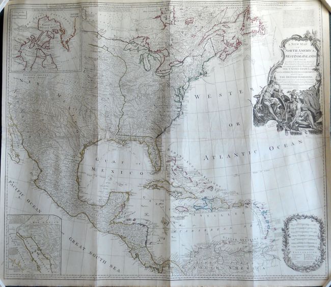
“A New Map of North America, with the West India Islands, Divided According to the Preliminary Articles of Peace Signed at Versailles 20 Jan. 1783, wherein are Particularly Distinguished the United States and the Several Provinces, Governments…”
Map Maker:
Laurie & Whittle
This large, influential map had a long and varied ... (full text available to subscribers)
| Item Detail |
| |
| |
MapMaker: |
Laurie & Whittle
|
|
| |
| |
Subject: |
North America |
|
| |
Period/Size: |
1794 / 39.8" x 45.5" (101.1 x 115.6 cm)
|
|
| |
Color: |
Colored
|
|
| |
Condition: |
Nice impression and original outline color. There is some faint scattered foxing that is unobtrusive and a repaired 2" tear at bottom just below the South Sea. Overall nice condition for such a large map. (condition help) |
|
| |
Source: |
|
|
| |
References: |
Stevens & Tree #49k. |
|
| |
|
|
| Sales Information |
| |
| |
Price: |
|
|
| |
| |
Offered by: |
Old World Auctions |
|
| |
Catalog: |
Auction No. 133 - Antique Maps, Charts, Atlases & Globes (7404) |
|
| |
Lot/Item #: |
101 |
|
| |
| |
Date: |
09/2010
|
|
| |
| |
|
Antique Maps - Valuation and Pricing, Descriptions, Resources |
|
Home |
Information |
Search |
Register |
Contact Us |
Site Map
Americana Exchange, Inc. © 1999 - 2024 Americana Exchange, Inc.. All rights reserved.
OldMaps.com, the OldMaps.com logo and
AMPR are service marks or registered service marks of Americana Exchange, Inc..
|