Title:
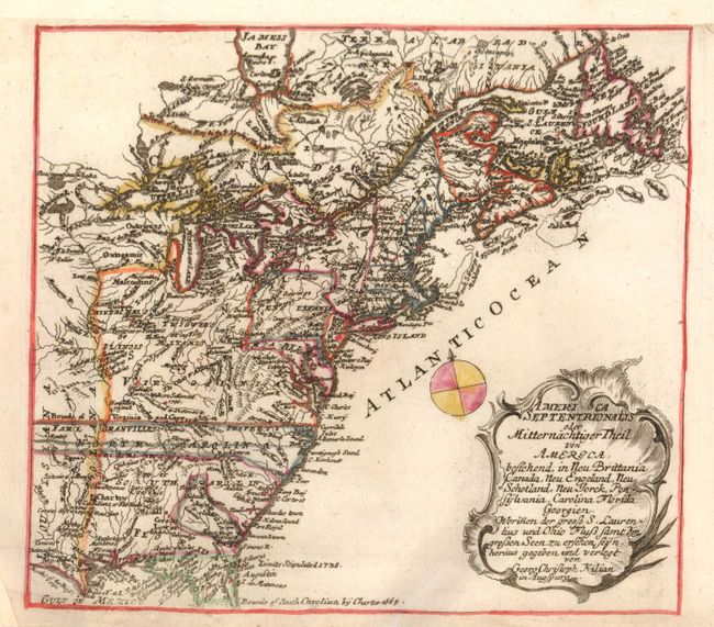
“America Septentrionalis oder Mitternachtiger Theil von America, Bestehend, in Neu Brittania Canada, Neu Engeland, Neu Schotland, Neu Jorck, Pensylvania, Carolina Florida Georgien. Worinnen der Grosse S. Laurentius und Ohio Fluss Samt…”
Map Maker:
George Christophe Kilian
This uncommon, little German map was based on Homa... (full text available to subscribers)
| Item Detail |
| |
| |
MapMaker: |
George Christophe Kilian
|
|
| |
| |
Subject: |
Colonial United States and Canada |
|
| |
Period/Size: |
1764 / 8.0" x 9.0" (20.4 x 22.9 cm)
|
|
| |
Color: |
Colored
|
|
| |
Condition: |
The binding margin at top has been extended to accommodate framing and some missing paper has been added in the bottom corners, well away from the map. (condition help) |
|
| |
Source: |
|
|
| |
References: |
|
|
| |
|
|
| Sales Information |
| |
| |
Price: |
|
|
| |
| |
Offered by: |
Old World Auctions |
|
| |
Catalog: |
Auction No. 133 - Antique Maps, Charts, Atlases & Globes (7404) |
|
| |
Lot/Item #: |
110 |
|
| |
| |
Date: |
09/2010
|
|
| |
| |
|
Antique Maps - Valuation and Pricing, Descriptions, Resources |
|
Home |
Information |
Search |
Register |
Contact Us |
Site Map
Americana Exchange, Inc. © 1999 - 2024 Americana Exchange, Inc.. All rights reserved.
OldMaps.com, the OldMaps.com logo and
AMPR are service marks or registered service marks of Americana Exchange, Inc..
|