Title:
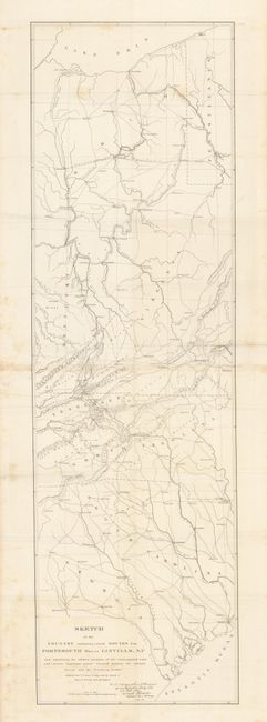
“Sketch of the Country embracing several Routes from Portsmouth Ohio, to Linville, N.C. and exhibiting the relative positions of the contemplated roadģbetween the Atlantic Ocean and the Northern Lakes”
Map Maker:
U.S. Corps of Engineers
This map details the country between Lake Erie sou... (full text available to subscribers)
| Item Detail |
| |
| |
MapMaker: |
U.S. Corps of Engineers
|
|
| |
| |
Subject: |
Mid-Atlantic and Southeast |
|
| |
Period/Size: |
1832-36 / 40.5" x 12.2" (102.9 x 31.0 cm)
|
|
| |
Color: |
Black & White
|
|
| |
Condition: |
Folding as issued. Nice example with some edge toning and a few marginal foxing spots. (condition help) |
|
| |
Source: |
|
|
| |
References: |
|
|
| |
|
|
| Sales Information |
| |
| |
Price: |
|
|
| |
| |
Offered by: |
Old World Auctions |
|
| |
Catalog: |
Auction No. 133 - Antique Maps, Charts, Atlases & Globes (7404) |
|
| |
Lot/Item #: |
160 |
|
| |
| |
Date: |
09/2010
|
|
| |
| |
|
Antique Maps - Valuation and Pricing, Descriptions, Resources |
|
Home |
Information |
Search |
Register |
Contact Us |
Site Map
Americana Exchange, Inc. © 1999 - 2024 Americana Exchange, Inc.. All rights reserved.
OldMaps.com, the OldMaps.com logo and
AMPR are service marks or registered service marks of Americana Exchange, Inc..
|