Title:
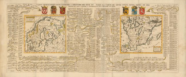
“Carte Genealogique pour Conduire a l'Histoire des Rois du Nord, la Carte de leurs Etats, leurs armes et des Remarques pour Conduire a l'Intelligence de l'Histoire du Nord”
Map Maker:
Henry Abraham Chatelain
This interesting large engraving features two maps... (full text available to subscribers)
| Item Detail |
| |
| |
MapMaker: |
Henry Abraham Chatelain
|
|
| |
| |
Subject: |
Scandinavia |
|
| |
Period/Size: |
1720 / 15.0" x 37.5" (38.1 x 95.3 cm)
|
|
| |
Color: |
Colored
|
|
| |
Condition: |
Overall very good with just a hint of toning along the paper joint and in the blank margins. A tiny fold separation in the margin is closed with archival tape. (condition help) |
|
| |
Source: |
Atlas Historique… |
|
| |
References: |
|
|
| |
|
|
| Sales Information |
| |
| |
Price: |
|
|
| |
| |
Offered by: |
Old World Auctions |
|
| |
Catalog: |
Auction No. 133 - Antique Maps, Charts, Atlases & Globes (7404) |
|
| |
Lot/Item #: |
408 |
|
| |
| |
Date: |
09/2010
|
|
| |
| |
|
Antique Maps - Valuation and Pricing, Descriptions, Resources |
|
Home |
Information |
Search |
Register |
Contact Us |
Site Map
Americana Exchange, Inc. © 1999 - 2024 Americana Exchange, Inc.. All rights reserved.
OldMaps.com, the OldMaps.com logo and
AMPR are service marks or registered service marks of Americana Exchange, Inc..
|