Title:
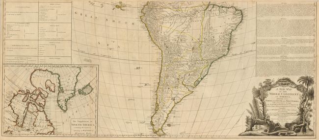
“A New Map of the Whole Continent of America, Divided into North and South and West Indies…”
Map Maker:
Sayer & Bennett
This impressive, large-scale map of North and Sout... (full text available to subscribers)
| Item Detail |
| |
| |
MapMaker: |
Sayer & Bennett
|
|
| |
| |
Subject: |
Western Hemisphere |
|
| |
Period/Size: |
1777 / 20.5" x 46.5" (52.1 x 118.2 cm)
|
|
| |
Color: |
Colored
|
|
| |
Condition: |
Nice impression and original outline color with some light toning and offsetting. (condition help) |
|
| |
Source: |
The General Atlas |
|
| |
References: |
Tooley (Amer) p. 51, #3c; Stevens & Tree #3c. |
|
| |
|
|
| Sales Information |
| |
| |
Price: |
|
|
| |
| |
Offered by: |
Old World Auctions |
|
| |
Catalog: |
Auction No. 134 - Antique Maps, Charts, Atlases & Globes (7405) |
|
| |
Lot/Item #: |
88 |
|
| |
| |
Date: |
12/2010
|
|
| |
| |
|
Antique Maps - Valuation and Pricing, Descriptions, Resources |
|
Home |
Information |
Search |
Register |
Contact Us |
Site Map
Americana Exchange, Inc. © 1999 - 2024 Americana Exchange, Inc.. All rights reserved.
OldMaps.com, the OldMaps.com logo and
AMPR are service marks or registered service marks of Americana Exchange, Inc..
|