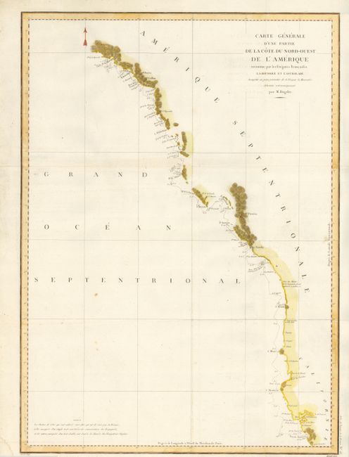
Title:
“Carte Generale d'une Partie de la Cote du Nord-Ouest de l'Amerique reconnue par les Fregates Francaises la Boussole et l'Astrolabe”
Map Maker:
Jean Francois Galaup de La Perouse
This is a superb large-scale map of the exploratio... (full text available to subscribers)
| Item Detail |
| |
| |
MapMaker: |
Jean Francois Galaup de La Perouse
|
|
| |
| |
Subject: |
Western Canada & United States |
|
| |
Period/Size: |
1797 / 27.0" x 19.5" (68.6 x 49.6 cm)
|
|
| |
Color: |
Colored
|
|
| |
Condition: |
Near flawless example except for a few tiny spots in the blank Pacific and an area of paper weakness from paper making process at the extreme left edge. An exceptional example that is very nicely colored. Folding as issued. (condition help) |
|
| |
Source: |
Atlas du Voyage de la Perouse |
|
| |
References: |
Falk #1797-8; Wagner (NW) #840. |
|
| |
|
|
| Sales Information |
| |
| |
Price: |
|
|
| |
| |
Offered by: |
Old World Auctions |
|
| |
Catalog: |
Auction No. 134 - Antique Maps, Charts, Atlases & Globes (7405) |
|
| |
Lot/Item #: |
134 |
|
| |
| |
Date: |
12/2010
|
|
| |
| |
|
Antique Maps - Valuation and Pricing, Descriptions, Resources |
|
Home |
Information |
Search |
Register |
Contact Us |
Site Map
Americana Exchange, Inc. © 1999 - 2024 Americana Exchange, Inc.. All rights reserved.
OldMaps.com, the OldMaps.com logo and
AMPR are service marks or registered service marks of Americana Exchange, Inc..
|