Title:
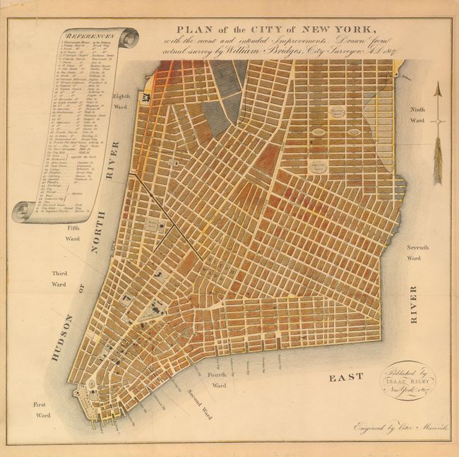
“Plan of the City of New York, with the recent and intended Improvements. Drawn from actual Survey by William Bridges, City Surveyor”
Map Maker:
William Bridges
This is William Bridges’ version of the failed 180... (full text available to subscribers)
| Item Detail |
| |
| |
MapMaker: |
William Bridges
|
|
| |
| |
Subject: |
New York City |
|
| |
Period/Size: |
1807 / 12.2" x 12.8" (31.0 x 32.6 cm)
|
|
| |
Color: |
Colored
|
|
| |
Condition: |
Issued folding, now flattened and mounted on linen. Light and even age toning. Very nice impression and full margins. The linen has several small areas of discoloration, that do not bleed-through to the map, apparently from old framing. (condition help) |
|
| |
Source: |
Picture of New York |
|
| |
References: |
Augustyn & Cohen pp. 98-99. |
|
| |
|
|
| Sales Information |
| |
| |
Price: |
|
|
| |
| |
Offered by: |
Old World Auctions |
|
| |
Catalog: |
Auction No. 134 - Antique Maps, Charts, Atlases & Globes (7405) |
|
| |
Lot/Item #: |
266 |
|
| |
| |
Date: |
12/2010
|
|
| |
| |
|
Antique Maps - Valuation and Pricing, Descriptions, Resources |
|
Home |
Information |
Search |
Register |
Contact Us |
Site Map
Americana Exchange, Inc. © 1999 - 2024 Americana Exchange, Inc.. All rights reserved.
OldMaps.com, the OldMaps.com logo and
AMPR are service marks or registered service marks of Americana Exchange, Inc..
|