Rister or Sign In to see pricing information


Title:

Port de Rhode Island et Narraganset Baye…

Map Maker:

George Louis Le Rouge

Port de Rhode Island et Narraganset Baye…

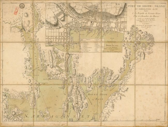
This important and scarce, Revolutionary War
Item Detail
 
  MapMaker:  

George Louis Le Rouge


  Subject:  Rhode Island  
  Period/Size:  1778 / 20.0" x 27.6"  (50.8 x 70.1 cm)  
  Color:  Colored  
  Condition:  There are some minor holes at the fold intersections and some soiling and foxing else is good or better. There are two very old stamps in the upper left, one is from the French War Department. (condition help)  
  Source:  Pilote americain septenentrionale  
  References:  Sellers & Van Ee #1000  
 
 
Sales Information
 
  Price: 

Please register your email to view records, or sign in with email address to see records


  Offered by:  Old World Auctions  
  Catalog:  Auction No. 134 - Antique Maps, Charts, Atlases & Globes (7405)  
  Lot/Item #:  280  
 
  Date:  12/2010  


Antique Maps - Valuation and Pricing, Descriptions, Resources


Home | Information | Search | Register | Contact Us | Site Map

Americana Exchange, Inc. © 1999 - 2024 Americana Exchange, Inc.. All rights reserved. OldMaps.com, the OldMaps.com logo and
AMPR are service marks or registered service marks of Americana Exchange, Inc..