Title:
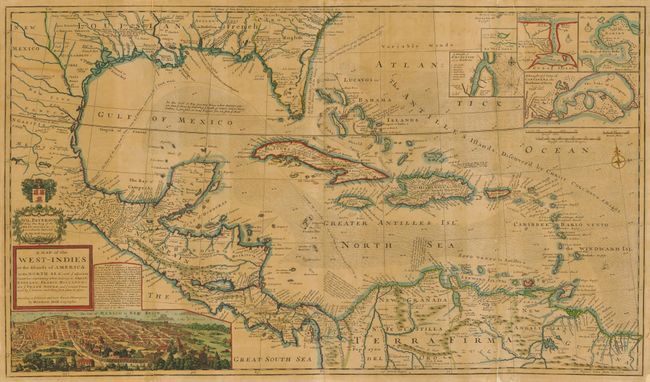
“A Map of the West-Indies or the Islands of America in the North Sea; with ye adjacent Countries; explaning what belongs to Spain, England, France, Holland &c. also ye Trade Winds, and ye several Tracts made by ye Galeons and Flota from Place to Place”
Map Maker:
Herman Moll
This large and incredible chart is filled with so ... (full text available to subscribers)
| Item Detail |
| |
| |
MapMaker: |
Herman Moll
|
|
| |
| |
Subject: |
Gulf of Mexico and Caribbean |
|
| |
Period/Size: |
1720 / 23.0" x 40.0" (58.5 x 101.6 cm)
|
|
| |
Color: |
Colored
|
|
| |
Condition: |
The map is toned overall and professionally backed with laid paper. There is minor loss along a couple of folds, but is overall attractive and stable. (condition help) |
|
| |
Source: |
|
|
| |
References: |
|
|
| |
|
|
| Sales Information |
| |
| |
Price: |
|
|
| |
| |
Offered by: |
Old World Auctions |
|
| |
Catalog: |
Auction No. 134 - Antique Maps, Charts, Atlases & Globes (7405) |
|
| |
Lot/Item #: |
309 |
|
| |
| |
Date: |
12/2010
|
|
| |
| |
|
Antique Maps - Valuation and Pricing, Descriptions, Resources |
|
Home |
Information |
Search |
Register |
Contact Us |
Site Map
Americana Exchange, Inc. © 1999 - 2024 Americana Exchange, Inc.. All rights reserved.
OldMaps.com, the OldMaps.com logo and
AMPR are service marks or registered service marks of Americana Exchange, Inc..
|