Title:
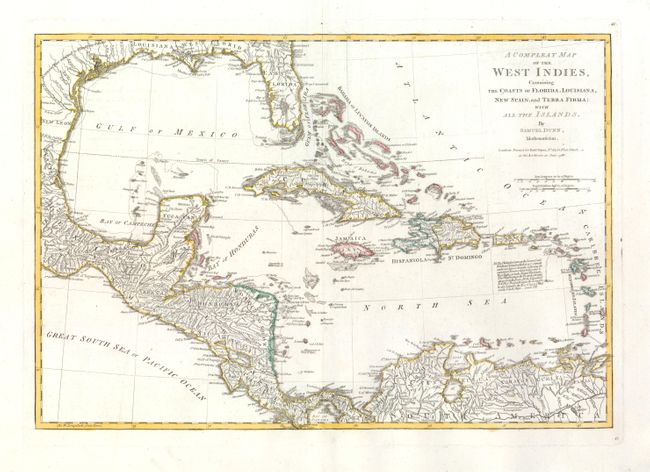
“A Compleat Map of the West Indies, Containing the Coasts of Florida, Louisiana, New Spain, and Terra Firma; with all the Islands”
Map Maker:
Samuel Dunn
This scarce map was drawn by Samuel Dunn, Mathemat... (full text available to subscribers)
| Item Detail |
| |
| |
MapMaker: |
Samuel Dunn
|
|
| |
| |
Subject: |
Gulf of Mexico and Caribbean |
|
| |
Period/Size: |
1786 / 12.0" x 17.5" (30.5 x 44.5 cm)
|
|
| |
Color: |
Colored
|
|
| |
Condition: |
An exceptionally beautiful example with fine coloring and dark impression on a sheet of thick hand laid paper with wide margins. Large fleur-de-lis watermark. A few tiny pin holes visible when held to light, still fine. (condition help) |
|
| |
Source: |
West-India Atlas |
|
| |
References: |
Sellers & Van Ee #1697. |
|
| |
|
|
| Sales Information |
| |
| |
Price: |
|
|
| |
| |
Offered by: |
Old World Auctions |
|
| |
Catalog: |
Auction No. 134 - Antique Maps, Charts, Atlases & Globes (7405) |
|
| |
Lot/Item #: |
312 |
|
| |
| |
Date: |
12/2010
|
|
| |
| |
|
Antique Maps - Valuation and Pricing, Descriptions, Resources |
|
Home |
Information |
Search |
Register |
Contact Us |
Site Map
Americana Exchange, Inc. © 1999 - 2024 Americana Exchange, Inc.. All rights reserved.
OldMaps.com, the OldMaps.com logo and
AMPR are service marks or registered service marks of Americana Exchange, Inc..
|