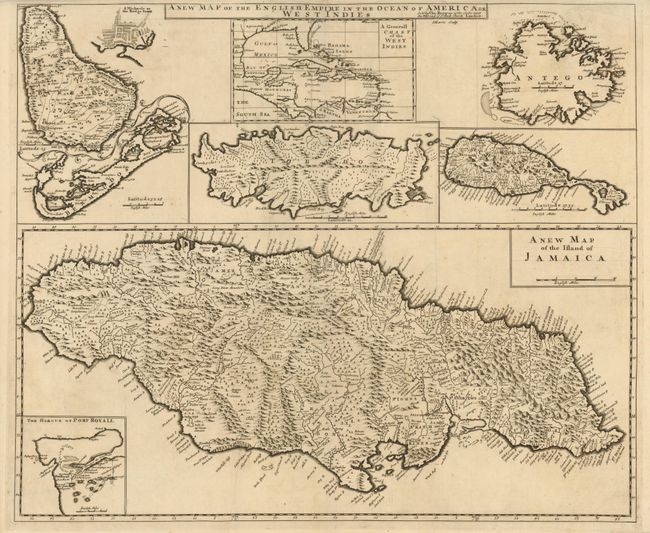
Title:
“A New Map of the English Empire in the Ocean of America or West Indies”
Map Maker:
Christopher Browne
This is the rare first edition of this composite s... (full text available to subscribers)
| Item Detail |
| |
| |
MapMaker: |
Christopher Browne
|
|
| |
| |
Subject: |
Caribbean |
|
| |
Period/Size: |
1690 / 19.8" x 23.8" (50.3 x 60.5 cm)
|
|
| |
Color: |
Black & White
|
|
| |
Condition: |
Sharp, early impression with a couple tiny repaired edge tears in top margin. (condition help) |
|
| |
Source: |
|
|
| |
References: |
|
|
| |
|
|
| Sales Information |
| |
| |
Price: |
|
|
| |
| |
Offered by: |
Old World Auctions |
|
| |
Catalog: |
Auction No. 134 - Antique Maps, Charts, Atlases & Globes (7405) |
|
| |
Lot/Item #: |
316 |
|
| |
| |
Date: |
12/2010
|
|
| |
| |
|
Antique Maps - Valuation and Pricing, Descriptions, Resources |
|
Home |
Information |
Search |
Register |
Contact Us |
Site Map
Americana Exchange, Inc. © 1999 - 2024 Americana Exchange, Inc.. All rights reserved.
OldMaps.com, the OldMaps.com logo and
AMPR are service marks or registered service marks of Americana Exchange, Inc..
|