Title:
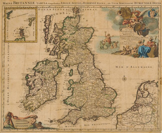
“Les Isles Britanniques qui contiennent les Royaumes d'Angleterre, Escosse, et Irlande…”
Map Maker:
Alexis-Hubert Jaillot
Second edition of this decorative folio map of the... (full text available to subscribers)
| Item Detail |
| |
| |
MapMaker: |
Alexis-Hubert Jaillot
|
|
| |
| |
Subject: |
Britain |
|
| |
Period/Size: |
1696 / 18.7" x 23.4" (47.5 x 59.5 cm)
|
|
| |
Color: |
Colored
|
|
| |
Condition: |
The paper is sound and the impression is very dark. The original color is somewhat faded and the map is toned overall with some minor foxing and damp stains. There is a separation of the fold at top that enters the border. There are remnants of framer' (condition help) |
|
| |
Source: |
Atlas Royal |
|
| |
References: |
Phillips (A) #5953-15; Shirley (BI) Jaillot 4. |
|
| |
|
|
| Sales Information |
| |
| |
Price: |
|
|
| |
| |
Offered by: |
Old World Auctions |
|
| |
Catalog: |
Auction No. 134 - Antique Maps, Charts, Atlases & Globes (7405) |
|
| |
Lot/Item #: |
400 |
|
| |
| |
Date: |
12/2010
|
|
| |
| |
|
Antique Maps - Valuation and Pricing, Descriptions, Resources |
|
Home |
Information |
Search |
Register |
Contact Us |
Site Map
Americana Exchange, Inc. © 1999 - 2024 Americana Exchange, Inc.. All rights reserved.
OldMaps.com, the OldMaps.com logo and
AMPR are service marks or registered service marks of Americana Exchange, Inc..
|