Title:
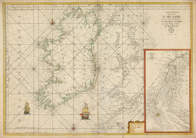
“Carte Generale des Costes d'Irlande, et des Costes Occidentales d'Angleterre avec une Partie de celles d'Ecosse”
Map Maker:
Jacques Nicolas Bellin
This superb, large-scale chart covers Ireland and ... (full text available to subscribers)
| Item Detail |
| |
| |
MapMaker: |
Jacques Nicolas Bellin
|
|
| |
| |
Subject: |
Ireland |
|
| |
Period/Size: |
1760 / 23.8" x 33.8" (60.5 x 85.9 cm)
|
|
| |
Color: |
Colored
|
|
| |
Condition: |
Very nice example with very nice impression on thick paper with full margins. Centerfold with light toning and short splits at ends, otherwise very good. (condition help) |
|
| |
Source: |
Hydrographie Francoise… |
|
| |
References: |
|
|
| |
|
|
| Sales Information |
| |
| |
Price: |
|
|
| |
| |
Offered by: |
Old World Auctions |
|
| |
Catalog: |
Auction No. 134 - Antique Maps, Charts, Atlases & Globes (7405) |
|
| |
Lot/Item #: |
434 |
|
| |
| |
Date: |
12/2010
|
|
| |
| |
|
Antique Maps - Valuation and Pricing, Descriptions, Resources |
|
Home |
Information |
Search |
Register |
Contact Us |
Site Map
Americana Exchange, Inc. © 1999 - 2024 Americana Exchange, Inc.. All rights reserved.
OldMaps.com, the OldMaps.com logo and
AMPR are service marks or registered service marks of Americana Exchange, Inc..
|