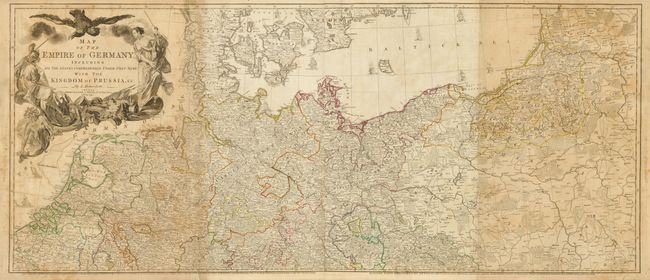
Title:
“Map of the Empire of Germany, Including All the States Comprehended under that Name: with the Kingdom of Prussia, &c.”
Map Maker:
Louis Stanislas d'Arcy Delarochette
This large, well-detailed map covers the German Em... (full text available to subscribers)
| Item Detail |
| |
| |
MapMaker: |
Louis Stanislas d'Arcy Delarochette
|
|
| |
| |
Subject: |
Central Europe, Germany |
|
| |
Period/Size: |
1794 / 40.5" x 47.0" (102.9 x 119.4 cm)
|
|
| |
Color: |
Colored
|
|
| |
Condition: |
Original outline color with some minor foxing. Two sections are darker toned that the others and there are some creases along a couple of folds. There is a short repaired tear at the bottom left of the top sheet that would be covers if the sheets were j (condition help) |
|
| |
Source: |
General Atlas |
|
| |
References: |
|
|
| |
|
|
| Sales Information |
| |
| |
Price: |
|
|
| |
| |
Offered by: |
Old World Auctions |
|
| |
Catalog: |
Auction No. 134 - Antique Maps, Charts, Atlases & Globes (7405) |
|
| |
Lot/Item #: |
492 |
|
| |
| |
Date: |
12/2010
|
|
| |
| |
|
Antique Maps - Valuation and Pricing, Descriptions, Resources |
|
Home |
Information |
Search |
Register |
Contact Us |
Site Map
Americana Exchange, Inc. © 1999 - 2024 Americana Exchange, Inc.. All rights reserved.
OldMaps.com, the OldMaps.com logo and
AMPR are service marks or registered service marks of Americana Exchange, Inc..
|