Rister or Sign In to see pricing information


Title:

Karte des Mittellaendischen Meers

Map Maker:

Franz Anton Schrambl

Karte des Mittellaendischen Meers

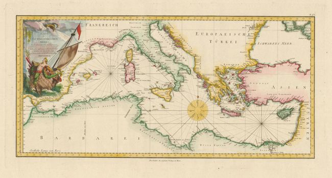
This is a scarce Austrian issue of Bonne's superb... (full text available to subscribers)
Item Detail
 
  MapMaker:  

Franz Anton Schrambl


  Subject:  Mediterranean  
  Period/Size:  1787 / 12.5" x 26.0"  (31.8 x 66.1 cm)  
  Color:  Colored  
  Condition:  Sharp impression and extremely wide original margins. There is a small rust spot in the bottom margin, well away from the map. (condition help)  
  Source:   
  References:   
 
 
Sales Information
 
  Price: 

Please register your email to view records, or sign in with email address to see records


  Offered by:  Old World Auctions  
  Catalog:  Auction No. 134 - Antique Maps, Charts, Atlases & Globes (7405)  
  Lot/Item #:  572  
 
  Date:  12/2010  


Antique Maps - Valuation and Pricing, Descriptions, Resources


Home | Information | Search | Register | Contact Us | Site Map

Americana Exchange, Inc. © 1999 - 2024 Americana Exchange, Inc.. All rights reserved. OldMaps.com, the OldMaps.com logo and
AMPR are service marks or registered service marks of Americana Exchange, Inc..