Title:
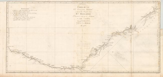
“Carte de la Nle. Galles Merid. ou de la Cote Oriental de la Nle. Hollande Decouverte et Visitee par le Lieutenant J. Cook, Commandant de l'Endeavor, Vaisseau de sa Majeste en 1770”
Map Maker:
Cook/Benard
This important map documents the first European di... (full text available to subscribers)
| Item Detail |
| |
| |
MapMaker: |
Cook/Benard
|
|
| |
| |
Subject: |
Australia |
|
| |
Period/Size: |
1774 / 14.2" x 30.6" (36.1 x 77.8 cm)
|
|
| |
Color: |
Black & White
|
|
| |
Condition: |
Folding as issued with some offsetting and light foxing. The right margin has been trimmed nearly to the neatline for binding and there is a short tear just into the border. (condition help) |
|
| |
Source: |
|
|
| |
References: |
Tooley (MCC-64) #342. |
|
| |
|
|
| Sales Information |
| |
| |
Price: |
|
|
| |
| |
Offered by: |
Old World Auctions |
|
| |
Catalog: |
Auction No. 134 - Antique Maps, Charts, Atlases & Globes (7405) |
|
| |
Lot/Item #: |
718 |
|
| |
| |
Date: |
12/2010
|
|
| |
| |
|
Antique Maps - Valuation and Pricing, Descriptions, Resources |
|
Home |
Information |
Search |
Register |
Contact Us |
Site Map
Americana Exchange, Inc. © 1999 - 2024 Americana Exchange, Inc.. All rights reserved.
OldMaps.com, the OldMaps.com logo and
AMPR are service marks or registered service marks of Americana Exchange, Inc..
|