Title:
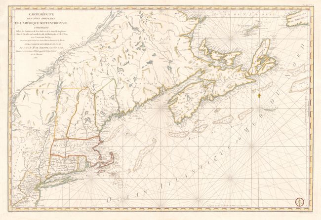
“Carte Reduite des Cotes Orientales de l'Amerique Septentrionale Contenant Celles des Provinces de New-York et de la Nouvelle Angleterre, Celles de l'Acadie ou Nouvelles Ecosse, de L'Ile Royale, de L'Ile St.Jean, avec L'Interieure du Pays…”
Map Maker:
Antoine de Sartine
This fine chart was prepared under the direction o... (full text available to subscribers)
| Item Detail |
| |
| |
MapMaker: |
Antoine de Sartine
|
|
| |
| |
Subject: |
Colonial New England and Canada |
|
| |
Period/Size: |
1780 / 23.0" x 34.3" (58.5 x 87.2 cm)
|
|
| |
Color: |
Colored
|
|
| |
Condition: |
Some worming in the chart has been professionally repaired and is now noticeable primarily on the verso. There is a minor tear in the blank margin, well away from the map. (condition help) |
|
| |
Source: |
Neptune Americo-Septentrional |
|
| |
References: |
McCorkle #780.3; Sellers & Van Ee #216. |
|
| |
|
|
| Sales Information |
| |
| |
Price: |
|
|
| |
| |
Offered by: |
Old World Auctions |
|
| |
Catalog: |
Auction No. 135 - Antique Maps, Charts, Atlases & Globes (7406) |
|
| |
Lot/Item #: |
132 |
|
| |
| |
Date: |
02/2011
|
|
| |
| |
|
Antique Maps - Valuation and Pricing, Descriptions, Resources |
|
Home |
Information |
Search |
Register |
Contact Us |
Site Map
Americana Exchange, Inc. © 1999 - 2024 Americana Exchange, Inc.. All rights reserved.
OldMaps.com, the OldMaps.com logo and
AMPR are service marks or registered service marks of Americana Exchange, Inc..
|