Title:
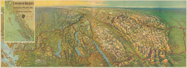
“Canadian Rockies Showing Main Line of Canadian Pacific Ry. with Branch Lines & Steamship Connections”
Map Maker:
Railroad Companies
This is a stunning bird's-eye view from the south ... (full text available to subscribers)
| Item Detail |
| |
| |
MapMaker: |
Railroad Companies
|
|
| |
| |
Subject: |
Western United States and Canada |
|
| |
Period/Size: |
1926 / 16.7" x 46.6" (42.5 x 118.4 cm)
|
|
| |
Color: |
Colored
|
|
| |
Condition: |
The folding view is very nice except for a small area of loss at left margin, otherwise fine. Map is loose from cover. Covers are soiled with repair on rear cover. (condition help) |
|
| |
Source: |
|
|
| |
References: |
|
|
| |
|
|
| Sales Information |
| |
| |
Price: |
|
|
| |
| |
Offered by: |
Old World Auctions |
|
| |
Catalog: |
Auction No. 135 - Antique Maps, Charts, Atlases & Globes (7406) |
|
| |
Lot/Item #: |
143 |
|
| |
| |
Date: |
02/2011
|
|
| |
| |
|
Antique Maps - Valuation and Pricing, Descriptions, Resources |
|
Home |
Information |
Search |
Register |
Contact Us |
Site Map
Americana Exchange, Inc. © 1999 - 2024 Americana Exchange, Inc.. All rights reserved.
OldMaps.com, the OldMaps.com logo and
AMPR are service marks or registered service marks of Americana Exchange, Inc..
|