Title:
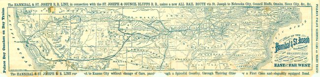
“Map of the Hannibal & St. Joseph Railroad Line and Connections. The Old Reliable Short Line route Between the East and the Far West”
Map Maker:
Fisk & Russell
This uncommon Railroad map and timetable self fold... (full text available to subscribers)
| Item Detail |
| |
| |
MapMaker: |
Fisk & Russell
|
|
| |
| |
Subject: |
United States |
|
| |
Period/Size: |
1870 / 5.3" x 25.0" (13.5 x 63.5 cm)
|
|
| |
Color: |
Colored
|
|
| |
Condition: |
The map is generally sound but has an area of light water stain along bottom. When folded the lower right tip is torn away which when opened presents several semi-circle areas of loss along the lower margin with some loss along the bottom that affects so (condition help) |
|
| |
Source: |
|
|
| |
References: |
|
|
| |
|
|
| Sales Information |
| |
| |
Price: |
|
|
| |
| |
Offered by: |
Old World Auctions |
|
| |
Catalog: |
Auction No. 135 - Antique Maps, Charts, Atlases & Globes (7406) |
|
| |
Lot/Item #: |
154 |
|
| |
| |
Date: |
02/2011
|
|
| |
| |
|
Antique Maps - Valuation and Pricing, Descriptions, Resources |
|
Home |
Information |
Search |
Register |
Contact Us |
Site Map
Americana Exchange, Inc. © 1999 - 2024 Americana Exchange, Inc.. All rights reserved.
OldMaps.com, the OldMaps.com logo and
AMPR are service marks or registered service marks of Americana Exchange, Inc..
|