Title:
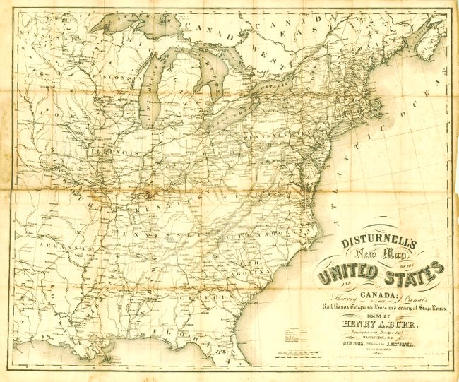
“Disturnell's New Map of the United States and Canada Showing All the Canals, Rail Roads, Telegraph Lines and Principal Stage Routes”
Map Maker:
Henry A. Burr
This map was drawn by Henry A. Burr, Topographer t... (full text available to subscribers)
| Item Detail |
| |
| |
MapMaker: |
Henry A. Burr
|
|
| |
| |
Subject: |
Eastern United States |
|
| |
Period/Size: |
1851 / 21.3" x 25.5" (54.1 x 64.8 cm)
|
|
| |
Color: |
Black & White
|
|
| |
Condition: |
The map has some fold intersection splits, one fold split at left, toned along some folds and with some scattered light foxing. The back cover and Disturnell map are together detached from the book. The spine is perished with the first few pages loose. (condition help) |
|
| |
Source: |
|
|
| |
References: |
|
|
| |
|
|
| Sales Information |
| |
| |
Price: |
|
|
| |
| |
Offered by: |
Old World Auctions |
|
| |
Catalog: |
Auction No. 135 - Antique Maps, Charts, Atlases & Globes (7406) |
|
| |
Lot/Item #: |
167 |
|
| |
| |
Date: |
02/2011
|
|
| |
| |
|
Antique Maps - Valuation and Pricing, Descriptions, Resources |
|
Home |
Information |
Search |
Register |
Contact Us |
Site Map
Americana Exchange, Inc. © 1999 - 2024 Americana Exchange, Inc.. All rights reserved.
OldMaps.com, the OldMaps.com logo and
AMPR are service marks or registered service marks of Americana Exchange, Inc..
|