Title:
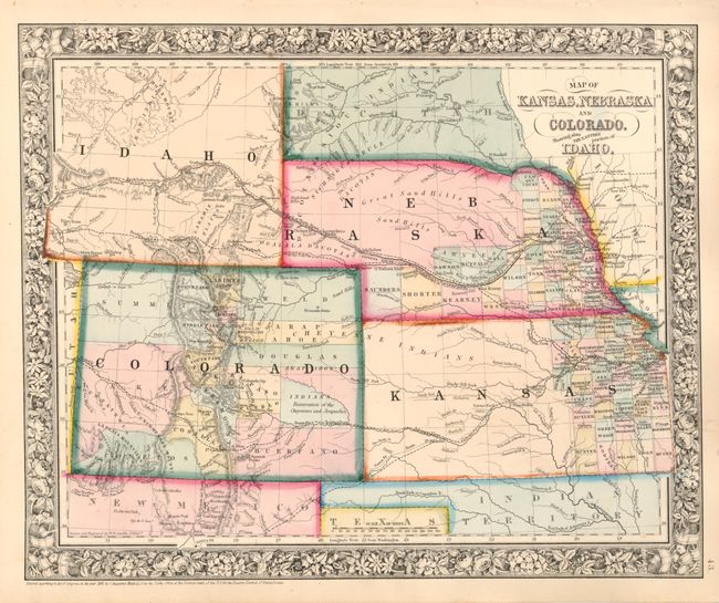
“Map of Kansas, Nebraska and Colorado, Showing also the Eastern Portion of Idaho”
Map Maker:
Samuel Augustus Mitchell
Mitchell's second edition of this map now shows th... (full text available to subscribers)
| Item Detail |
| |
| |
MapMaker: |
Samuel Augustus Mitchell
|
|
| |
| |
Subject: |
Central & Western United State |
|
| |
Period/Size: |
1861 / 11.5" x 14.0" (29.3 x 35.6 cm)
|
|
| |
Color: |
Colored
|
|
| |
Condition: |
Very nice example with full margins, strong impression and bright original color. (condition help) |
|
| |
Source: |
|
|
| |
References: |
Wheat (TMW) #1030. |
|
| |
|
|
| Sales Information |
| |
| |
Price: |
|
|
| |
| |
Offered by: |
Old World Auctions |
|
| |
Catalog: |
Auction No. 135 - Antique Maps, Charts, Atlases & Globes (7406) |
|
| |
Lot/Item #: |
210 |
|
| |
| |
Date: |
02/2011
|
|
| |
| |
|
Antique Maps - Valuation and Pricing, Descriptions, Resources |
|
Home |
Information |
Search |
Register |
Contact Us |
Site Map
Americana Exchange, Inc. © 1999 - 2024 Americana Exchange, Inc.. All rights reserved.
OldMaps.com, the OldMaps.com logo and
AMPR are service marks or registered service marks of Americana Exchange, Inc..
|