Title:
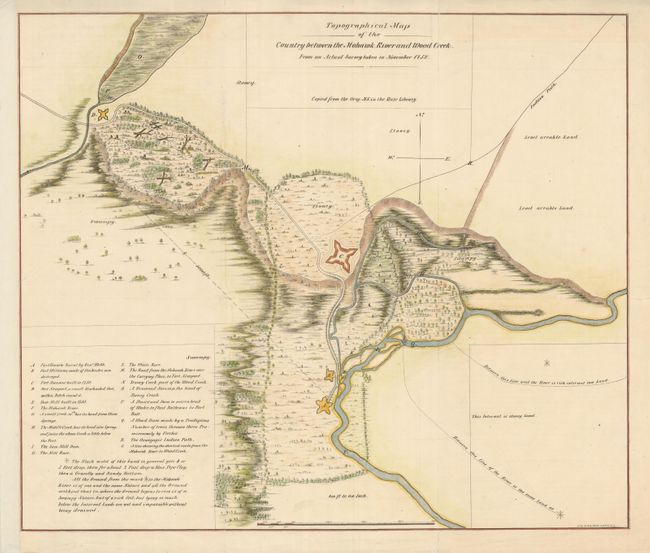
“Topographical Map of the Country between the Mohawk River and Wood Creek”
Map Maker:
Richard H. Pease
The is a very detailed, lithographed map of the co... (full text available to subscribers)
| Item Detail |
| |
| |
MapMaker: |
Richard H. Pease
|
|
| |
| |
Subject: |
New York |
|
| |
Period/Size: |
1850 / 16.8" x 20.0" (42.7 x 50.8 cm)
|
|
| |
Color: |
Colored
|
|
| |
Condition: |
Issued folded, now flattened and backed with archival tissue. Trimmed to neatline at left with paper added to margin. (condition help) |
|
| |
Source: |
The Documentary History of the State of New York |
|
| |
References: |
|
|
| |
|
|
| Sales Information |
| |
| |
Price: |
|
|
| |
| |
Offered by: |
Old World Auctions |
|
| |
Catalog: |
Auction No. 135 - Antique Maps, Charts, Atlases & Globes (7406) |
|
| |
Lot/Item #: |
310 |
|
| |
| |
Date: |
02/2011
|
|
| |
| |
|
Antique Maps - Valuation and Pricing, Descriptions, Resources |
|
Home |
Information |
Search |
Register |
Contact Us |
Site Map
Americana Exchange, Inc. © 1999 - 2024 Americana Exchange, Inc.. All rights reserved.
OldMaps.com, the OldMaps.com logo and
AMPR are service marks or registered service marks of Americana Exchange, Inc..
|