Title:
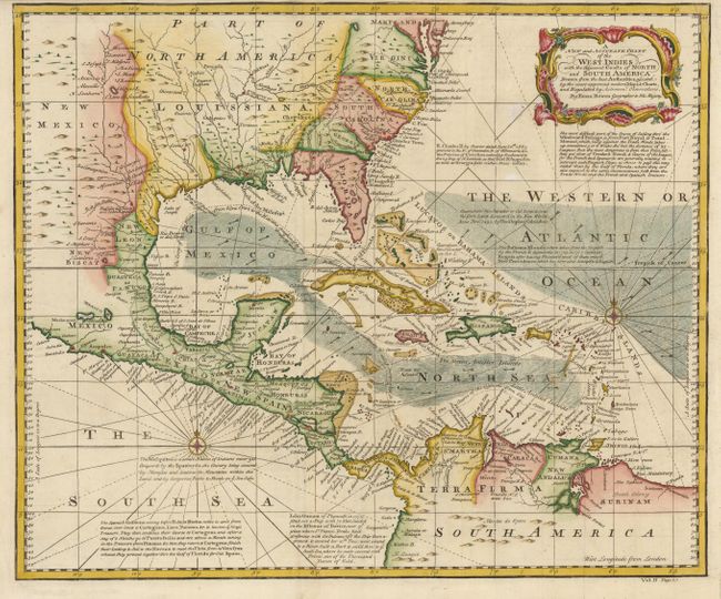
“A New and Accurate Chart of the West Indies with the Adjacent Coasts of North and South America. Drawn from the Best Authorities assisted by the most approved modern Maps & Charts…”
Map Maker:
Emanuel Bowen
A handsome map of the Caribbean and Gulf coasts wi... (full text available to subscribers)
| Item Detail |
| |
| |
MapMaker: |
Emanuel Bowen
|
|
| |
| |
Subject: |
Gulf of Mexico and Caribbean |
|
| |
Period/Size: |
1744 / 14.5" x 17.4" (36.9 x 44.2 cm)
|
|
| |
Color: |
Colored
|
|
| |
Condition: |
Nice impression and attractive color. (condition help) |
|
| |
Source: |
John Harris' Navigantium Atque… |
|
| |
References: |
|
|
| |
|
|
| Sales Information |
| |
| |
Price: |
|
|
| |
| |
Offered by: |
Old World Auctions |
|
| |
Catalog: |
Auction No. 135 - Antique Maps, Charts, Atlases & Globes (7406) |
|
| |
Lot/Item #: |
351 |
|
| |
| |
Date: |
02/2011
|
|
| |
| |
|
Antique Maps - Valuation and Pricing, Descriptions, Resources |
|
Home |
Information |
Search |
Register |
Contact Us |
Site Map
Americana Exchange, Inc. © 1999 - 2024 Americana Exchange, Inc.. All rights reserved.
OldMaps.com, the OldMaps.com logo and
AMPR are service marks or registered service marks of Americana Exchange, Inc..
|