Title:
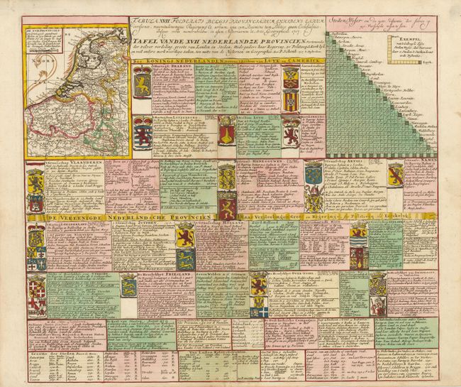
“Tafel vande XVII Nederlandze Provincien, Vertonende der zelver verdeling, grootte van Landen en Steden, mids-gaders haar Regering, zo Politiecq als Kerk-lyck, en veel andere merkweerdige zaken, ten nutte vande Historien en Geographie”
Map Maker:
Petrus Schenk
This interesting chart contains the coat of arms o... (full text available to subscribers)
| Item Detail |
| |
| |
MapMaker: |
Petrus Schenk
|
|
| |
| |
Subject: |
Low Countries |
|
| |
Period/Size: |
1707 / 18.8" x 21.4" (47.8 x 54.4 cm)
|
|
| |
Color: |
Colored
|
|
| |
Condition: |
Nice impression and original color with just a hint of light toning. (condition help) |
|
| |
Source: |
|
|
| |
References: |
|
|
| |
|
|
| Sales Information |
| |
| |
Price: |
|
|
| |
| |
Offered by: |
Old World Auctions |
|
| |
Catalog: |
Auction No. 135 - Antique Maps, Charts, Atlases & Globes (7406) |
|
| |
Lot/Item #: |
481 |
|
| |
| |
Date: |
02/2011
|
|
| |
| |
|
Antique Maps - Valuation and Pricing, Descriptions, Resources |
|
Home |
Information |
Search |
Register |
Contact Us |
Site Map
Americana Exchange, Inc. © 1999 - 2024 Americana Exchange, Inc.. All rights reserved.
OldMaps.com, the OldMaps.com logo and
AMPR are service marks or registered service marks of Americana Exchange, Inc..
|