Title:
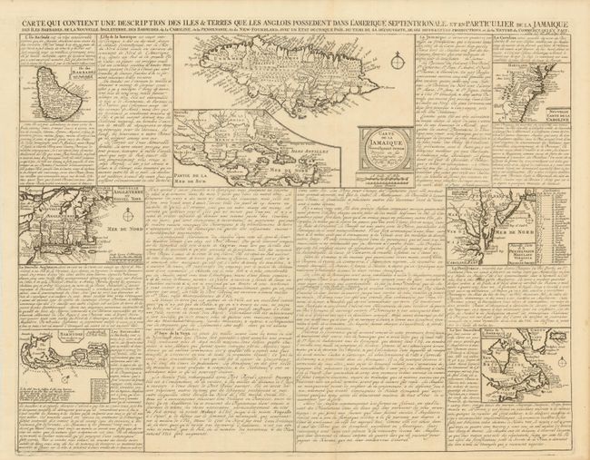
“Carte qui Contient une Description des Iles & Terres que les Anglois Possedent dans l'Amerique Septentrionale, et en Particulier de la Jamaique, des Iles Barbades, de la Nouvelle Angleterre, des Barmudes, de la Caroline, de la Pensilvanie …”
Map Maker:
Henry Abraham Chatelain
A very interesting folio sheet containing seven ma... (full text available to subscribers)
| Item Detail |
| |
| |
MapMaker: |
Henry Abraham Chatelain
|
|
| |
| |
Subject: |
Colonial North America, Caribbean & Bermuda |
|
| |
Period/Size: |
1719 / 16.0" x 20.5" (40.7 x 52.1 cm)
|
|
| |
Color: |
Black & White
|
|
| |
Condition: |
There is an old paper repair on a short fold separation at bottom and hinge remnants on verso. (condition help) |
|
| |
Source: |
Atlas Historique… |
|
| |
References: |
McCorkle #719.3. |
|
| |
|
|
| Sales Information |
| |
| |
Price: |
|
|
| |
| |
Offered by: |
Old World Auctions |
|
| |
Catalog: |
Auction No. 136 - Antique Maps, Charts, Atlases & Globes (7407) |
|
| |
Lot/Item #: |
105 |
|
| |
| |
Date: |
06/2011
|
|
| |
| |
|
Antique Maps - Valuation and Pricing, Descriptions, Resources |
|
Home |
Information |
Search |
Register |
Contact Us |
Site Map
Americana Exchange, Inc. © 1999 - 2024 Americana Exchange, Inc.. All rights reserved.
OldMaps.com, the OldMaps.com logo and
AMPR are service marks or registered service marks of Americana Exchange, Inc..
|