Title:
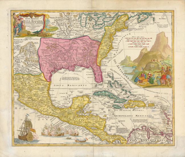
“Regni Mexicani seu Novae Hispaniae, Ludovicianae, N. Angliae, Carolinae, Virginiae, et Pensylvaniae nec non Insularum Archipelagi Mexicani in America Septentrionali Accurata Tabula…”
Map Maker:
Johann Baptist Homann
This superb map covers the region from the Great L... (full text available to subscribers)
| Item Detail |
| |
| |
MapMaker: |
Johann Baptist Homann
|
|
| |
| |
Subject: |
Colonial North America and Caribbean |
|
| |
Period/Size: |
1720 / 18.6" x 22.3" (47.3 x 56.7 cm)
|
|
| |
Color: |
Colored
|
|
| |
Condition: |
Has some staining in the lower quarters, and part of right-side margin has been trimmed to neat line and replaced. There is a repaired tear above ship at lower left, the Centerfold has been repaired, and there are some edge tears with a variety of repair (condition help) |
|
| |
Source: |
|
|
| |
References: |
Van Ermen p.42; Cumming (SE) #137; Manasek #72; Martin & Martin #17; Ste.Claire #8; Portinaro #CXV |
|
| |
|
|
| Sales Information |
| |
| |
Price: |
|
|
| |
| |
Offered by: |
Old World Auctions |
|
| |
Catalog: |
Auction No. 136 - Antique Maps, Charts, Atlases & Globes (7407) |
|
| |
Lot/Item #: |
107 |
|
| |
| |
Date: |
06/2011
|
|
| |
| |
|
Antique Maps - Valuation and Pricing, Descriptions, Resources |
|
Home |
Information |
Search |
Register |
Contact Us |
Site Map
Americana Exchange, Inc. © 1999 - 2024 Americana Exchange, Inc.. All rights reserved.
OldMaps.com, the OldMaps.com logo and
AMPR are service marks or registered service marks of Americana Exchange, Inc..
|