Title:
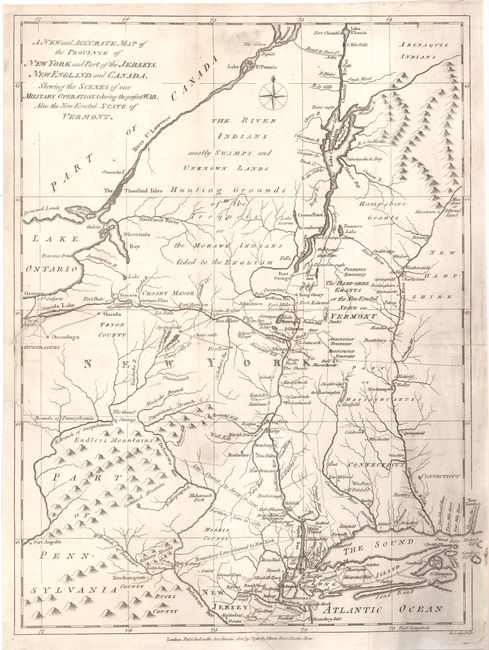
“A New and Accurate Map of the Province of New York and Part of the Jerseys, New England and Canada, Shewing the Scenes of our Military Operations during the present War. Also the New Erected State of Vermont”
Map Maker:
John Lodge
A detailed and interesting map of the field of mil... (full text available to subscribers)
| Item Detail |
| |
| |
MapMaker: |
John Lodge
|
|
| |
| |
Subject: |
Colonial New England and Mid-Atlantic |
|
| |
Period/Size: |
1780 / 14.5" x 10.8" (36.9 x 27.5 cm)
|
|
| |
Color: |
Black & White
|
|
| |
Condition: |
A nice example that was issued folding, now backed with archival tissue. A little soiling at lower left and a small smudge at top just below neatline. The hand laid paper has two watermarks including a large circular mark with a figure inside. (condition help) |
|
| |
Source: |
Political Magazine |
|
| |
References: |
Jolly POL-14; Sellers & van Ee #176; McCorkle #780-9. |
|
| |
|
|
| Sales Information |
| |
| |
Price: |
|
|
| |
| |
Offered by: |
Old World Auctions |
|
| |
Catalog: |
Auction No. 136 - Antique Maps, Charts, Atlases & Globes (7407) |
|
| |
Lot/Item #: |
193 |
|
| |
| |
Date: |
06/2011
|
|
| |
| |
|
Antique Maps - Valuation and Pricing, Descriptions, Resources |
|
Home |
Information |
Search |
Register |
Contact Us |
Site Map
Americana Exchange, Inc. © 1999 - 2024 Americana Exchange, Inc.. All rights reserved.
OldMaps.com, the OldMaps.com logo and
AMPR are service marks or registered service marks of Americana Exchange, Inc..
|