Title:
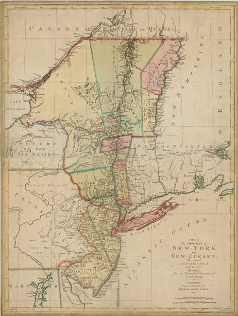
“A Map of the Provinces of New-York and New-Jersey, with a part of Pennsylvania and the Province of Quebec, from the Topographical Observations of C. J. Sauthier”
Map Maker:
Matthaus Albrecht Lotter
A beautiful Revolutionary War period map of... (full text available to subscribers)
| Item Detail |
| |
| |
MapMaker: |
Matthaus Albrecht Lotter
|
|
| |
| |
Subject: |
Colonial Mid-Atlantic |
|
| |
Period/Size: |
1777 / 29.5" x 22.1" (75.0 x 56.2 cm)
|
|
| |
Color: |
Colored
|
|
| |
Condition: |
Original color with light overall toning and some minor surface soil. (condition help) |
|
| |
Source: |
|
|
| |
References: |
McCorkle #777.20; Sellers & Van Ee #1048. |
|
| |
|
|
| Sales Information |
| |
| |
Price: |
|
|
| |
| |
Offered by: |
Old World Auctions |
|
| |
Catalog: |
Auction No. 136 - Antique Maps, Charts, Atlases & Globes (7407) |
|
| |
Lot/Item #: |
205 |
|
| |
| |
Date: |
06/2011
|
|
| |
| |
|
Antique Maps - Valuation and Pricing, Descriptions, Resources |
|
Home |
Information |
Search |
Register |
Contact Us |
Site Map
Americana Exchange, Inc. © 1999 - 2024 Americana Exchange, Inc.. All rights reserved.
OldMaps.com, the OldMaps.com logo and
AMPR are service marks or registered service marks of Americana Exchange, Inc..
|