Title:
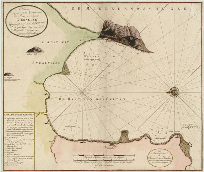
“Nieuwe en Seer nette Caart van de Baay en Stadt Gibraltar, Geteekent door den Wel Ede: Hr: H. Leysnslager…”
Map Maker:
Johannes van Keulen
This rare Dutch sea chart of the bay of Gibraltar ... (full text available to subscribers)
| Item Detail |
| |
| |
MapMaker: |
Johannes van Keulen
|
|
| |
| |
Subject: |
Gibraltar |
|
| |
Period/Size: |
1735 / 19.8" x 23.5" (50.3 x 59.7 cm)
|
|
| |
Color: |
Colored
|
|
| |
Condition: |
Narrow, but adequate margins with some soil and extraneous creasing along centerfold where there are a couple of minor repairs. (condition help) |
|
| |
Source: |
|
|
| |
References: |
|
|
| |
|
|
| Sales Information |
| |
| |
Price: |
|
|
| |
| |
Offered by: |
Old World Auctions |
|
| |
Catalog: |
Auction No. 136 - Antique Maps, Charts, Atlases & Globes (7407) |
|
| |
Lot/Item #: |
617 |
|
| |
| |
Date: |
06/2011
|
|
| |
| |
|
Antique Maps - Valuation and Pricing, Descriptions, Resources |
|
Home |
Information |
Search |
Register |
Contact Us |
Site Map
Americana Exchange, Inc. © 1999 - 2024 Americana Exchange, Inc.. All rights reserved.
OldMaps.com, the OldMaps.com logo and
AMPR are service marks or registered service marks of Americana Exchange, Inc..
|