Title:
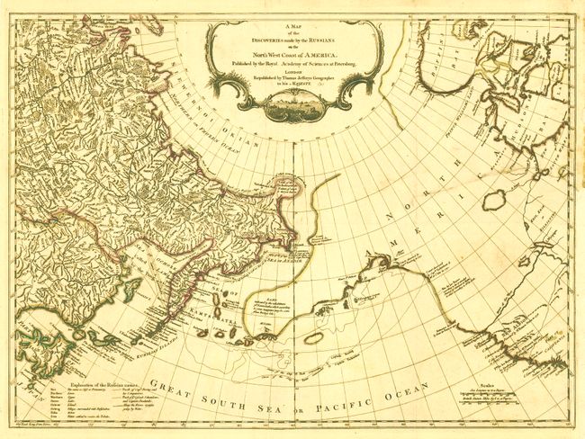
“A Map of the Discoveries made by the Russians on the North West Coast of America. Published by the Royal Academy of Sciences at Petersburg”
Map Maker:
Thomas Jefferys
This map, by Thomas Jefferys, is based on Gerhard ... (full text available to subscribers)
| Item Detail |
| |
| |
MapMaker: |
Thomas Jefferys
|
|
| |
| |
Subject: |
North Pacific Ocean |
|
| |
Period/Size: |
1761 / 17.8" x 24.5" (45.3 x 62.3 cm)
|
|
| |
Color: |
Colored
|
|
| |
Condition: |
Issued folding with original outline color. A 7" tear from right-hand side has been professionally repaired and does not distract. The binding trim has been replaced at right. Backed with Japanese tissue. (condition help) |
|
| |
Source: |
|
|
| |
References: |
Wagner (NW) #597; Falk #1761-3. |
|
| |
|
|
| Sales Information |
| |
| |
Price: |
|
|
| |
| |
Offered by: |
Old World Auctions |
|
| |
Catalog: |
Auction No. 136 - Antique Maps, Charts, Atlases & Globes (7407) |
|
| |
Lot/Item #: |
757 |
|
| |
| |
Date: |
06/2011
|
|
| |
| |
|
Antique Maps - Valuation and Pricing, Descriptions, Resources |
|
Home |
Information |
Search |
Register |
Contact Us |
Site Map
Americana Exchange, Inc. © 1999 - 2024 Americana Exchange, Inc.. All rights reserved.
OldMaps.com, the OldMaps.com logo and
AMPR are service marks or registered service marks of Americana Exchange, Inc..
|