Title:
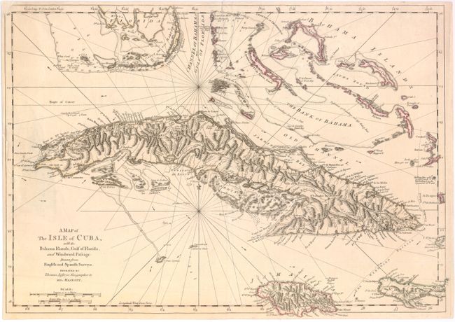
“A Map of the Isle of Cuba, with the Bahama Islands, Gulf of Florida, and Windward Passage…”
Map Maker:
Thomas Jefferys
This detailed map of Cuba shows town, villages, mo... (full text available to subscribers)
| Item Detail |
| |
| |
MapMaker: |
Thomas Jefferys
|
|
| |
| |
Subject: |
Cuba |
|
| |
Period/Size: |
1762 / 13.5" x 19.2" (34.3 x 48.8 cm)
|
|
| |
Color: |
Colored
|
|
| |
Condition: |
A 2" tear along map border at right has been closed on verso with Japanese tissue and the upper-left corner has been replaced with old paper, with minor loss of neatline. (condition help) |
|
| |
Source: |
|
|
| |
References: |
Sellers & Van Ee #1781; Lowery, W. #463. |
|
| |
|
|
| Sales Information |
| |
| |
Price: |
|
|
| |
| |
Offered by: |
Old World Auctions |
|
| |
Catalog: |
Auction No. 137 - Antique Maps, Charts, Atlases & Globes (7408) |
|
| |
Lot/Item #: |
436 |
|
| |
| |
Date: |
09/2011
|
|
| |
| |
|
Antique Maps - Valuation and Pricing, Descriptions, Resources |
|
Home |
Information |
Search |
Register |
Contact Us |
Site Map
Americana Exchange, Inc. © 1999 - 2024 Americana Exchange, Inc.. All rights reserved.
OldMaps.com, the OldMaps.com logo and
AMPR are service marks or registered service marks of Americana Exchange, Inc..
|