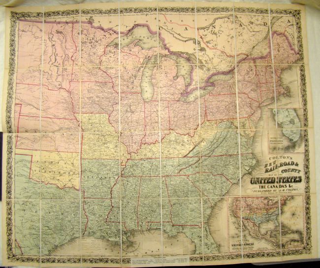
Title:
“Colton's New Railroad & County Map of the United States”
Map Maker:
Joseph Hutchins Colton
This is a rare Civil War era map showing the easte... (full text available to subscribers)
| Item Detail |
| |
| |
MapMaker: |
Joseph Hutchins Colton
|
|
| |
| |
Subject: |
United States |
|
| |
Period/Size: |
1862 / 33.0" x 39.5" (83.9 x 100.4 cm)
|
|
| |
Color: |
Colored
|
|
| |
Condition: |
The map is clean and bright with slight offsetting and toning. Dissected and mounted on linen. Folds into brown cloth covers with pastedown label. Map has an explanatory label in lower margin and border explaining the color coding of states. (condition help) |
|
| |
Source: |
|
|
| |
References: |
Stephenson #25.7; Rumsey 3358. |
|
| |
|
|
| Sales Information |
| |
| |
Price: |
|
|
| |
| |
Offered by: |
Old World Auctions |
|
| |
Catalog: |
Auction No. 137 - Antique Maps, Charts, Atlases & Globes (7408) |
|
| |
Lot/Item #: |
167 |
|
| |
| |
Date: |
09/2011
|
|
| |
| |
|
Antique Maps - Valuation and Pricing, Descriptions, Resources |
|
Home |
Information |
Search |
Register |
Contact Us |
Site Map
Americana Exchange, Inc. © 1999 - 2024 Americana Exchange, Inc.. All rights reserved.
OldMaps.com, the OldMaps.com logo and
AMPR are service marks or registered service marks of Americana Exchange, Inc..
|